The River Arun in West Sussex is crossed by several ancient bridges, including Greatham Bridge near Coldwaltham, which was originally built in the 13th Century, rebuilt in the 18th, adapted with a new span in the 19th and restored in the 21st.
In the 17th Century it was the scene of a minor battle during the English Civil War: the Parliamentarians seeking to wrest control of the strategic river crossing from the local Royalists. The graves of the dead from this skirmish can be found in the local churchyard.
The river itself was navigable in the 11th Century and by the 19th it connected to the Wey & Arun Canal, providing a link to London. As with all the inland waterways; demand fell away with the coming of the railways and maintenance of the navigation ceased in the 1890s.
The common along the western shore of the river is known as Waltham Brooks and is owned by Sussex Wildlife Trust. The line of the old navigation which here straightened a bend in the river can still be seen and still contains water. The remains of Coldwaltham Lock with its attendant keeper’s cottage are also present.
If you turn at the beautiful old farm at Bignor and drive up the narrow road onto the Downs, you will find a lane so steep and winding that you will be forced to change down into first gear to get the car up there. I have made this climb many times, both by car and on foot, but what I didn’t realise until yesterday was that as you make the second steep turn, you join Stane Street, the Roman Road from London Bridge to the East Gate of Chichester.
Not only that, but the “agger” of the old road itself can be clearly seen at the top of the hill, where the tarmac gives out, but the ancient route continues.
Now, I’ve been up to Bignor Hill dozens of times and I’d noticed this long, linear earthwork and, in my ignorance, had assumed that it must be some kind of medieval boundary marker. It was only a bit of idle map-perusal that led me to realise that this bank of earth was, in fact, built by Roman engineers nearly 2000 years ago!
So, of course, armed with this new knowledge I set off for a proper look. Eschewing my usual route along the edge of the scarp (which is beautiful), the old Road was easy to follow and, as it emerged from some trees it stretched so obviously ahead of me, towards Chichester I could scarcely believe it. As I walked back along the bank I’d seen before I couldn’t get over how clearly this was a road, now I’d seen it in the right way.
What a wonderful thing that a place one knows so well can turn out to have something so completely unexpected and exciting as this!
What a find! The estate of the Elizabethan former manor house of 1598, the whole lot was left to the Forestry Commission on the death of former owner William Robinson, who also created renowned gardens around the house, which are now open under restrictions. The house became a hotel and Michelin starred restaurant.
Because the estate is managed by the Forestry Commission, the whole lot is designated as Access Land and the public have the right to roam across all of it. Unlike most Forestry Commission properties it is far from being uniform pine plantation, but is in fact a wonderful extensive patchwork of woods, fields, lakes and streams laid over rolling hills and with the old manor house still set at its heart.
I have been to many beautiful places and there are those that equal, but none that surpass Wester Ross in the Scottish West Highlands for sheer beauty and grandeur. There may be bigger mountains in the world, the weather may be a bit tricky and the midges can be a challenge, but there’s nowhere quite like it. If you love walking in the hills, dramatic mountain and coastal scenery and some of the best seafood in the world, I urge you to go there.
Now, I don’t know how you spend your evenings, but I spend quite a lot of mine looking at Ordnance Survey maps. Mostly, of course, I’m looking for places with rude names (Wellcombe Bottom being a particular favourite), but also I’m looking for places that might be nice for a walk. One such place is an area of open access woodland I noticed to the north of Fittleworth in West Sussex (Fittleworth of course is not a rude name, exactly, but it’s still an awesome one). Today being a nice day, I decided to go and have a look… And found this! Built as a church and a school in 1880, it stopped being used for education in 1925 and for worship in 1959.
One of the best things about living in Brighton is how easy it is to get out to the countryside. Often I drive out to the Downs, or Ashdown Forest or somewhere, but this walk starts at my front door and within ten minutes I’ve left the city and the green fields are all around me.
Just the other side of the Downs from Brighton is a path that winds up the steep, northerly slopes called Burnhouse Bostall. For thousands of years shepherds lead their flocks up and down from the Weald to the Downs and back, carving these deep paths into the chalk as they went. Now the sheep are no longer driven up these paths, it is left to the rain and the boots of walkers to carry the job on.
The path fell steeply away at my feet as I entered Darwell Wood and I was quickly deep in the quiet, dreaming woodland. I could see on the map that I wasn’t far from the reservoir, but I couldn’t see it. My heart sank a little and I wondered if it would be the same as Weir Wood Reservoir, where only the barest glimpses of the water can be caught from the path and a high fence prevents getting any nearer. The path brought me to the long, gently winding incongruous sight of a covered conveyor belt, running through the trees: there are gypsum mines in these woods and the conveyor stretches for just under 5km between them. Turning away, the footpath drops once again and suddenly, to my delight, I could see the water through the trees. Fighting my way through dense willows, I emerged on the shore. What a beautiful place. I didn’t want to leave, but leave I did and looped back round through the woods to the car.
Ashdown Forest is a former hunting preserve in East Sussex and is now one of the largest areas of open access land in the South East of England. More open heath, riven with winding streams than dense woodland, the “forest” part of its name refers to its status as a hunting ground, from the original Norman French meaning of the word. Having said that, it does have woodland and that’s where I mostly was today.
Now, try not to get too excited, but we’re back at that exceptional beauty spot The Downs Hotel in Woodingdean (served, excitingly, by both the No. 22 and the No. 2). I know it’s tempting, but try to resist its obvious charms. There’s a Tesco Express at the petrol station as well as a Co-op just over the junction, but if you can tear yourself away, turn left at the Downs Hotel and walk up the hill on Falmer Road. Just past the end of the buildings on the right is a small car park with a couple of tracks leading from it. The left-hand track is Drove Avenue, which becomes Jugg’s Road and is a popular and straightforward route to Lewes, but not a patch on my route (obviously), which goes through Castle Hill National Nature Reserve and has some of the best dip-slope/dry valley scenery on the South Downs.
Take the Left Hand Fork
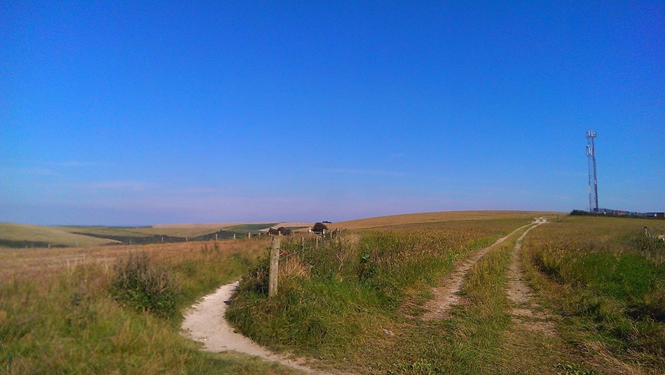
Follow the right-hand track, which I am sure you’ll be thrilled to know is called Norton Drive. Ahead of you, you will see a radio mast (you will also see, away to its left, another radio mast on the top of Newmarket Hill. So long as you’re heading initially towards the right hand of the two, you are going the right way. Well done!). Just before the radio mast, take the left-hand fork, with the fence on your right. This path, I have decided, is one of the most beautiful on the South Downs and I shall brook no argument on the matter. To your left is Newmarket Bottom and Bullock Hill rises on your right.
Follow the path all the way down and round to the right, round the end of Standean Bottom and back along the other side of the dry valley.
Have we talked about dry valleys? Let’s talk about dry valleys. The most famous dry valley on the South Downs is Devil’s Dyke and I’ll do a Devil’s Dyke walk at some point I’m sure, but the important thing is that they were all created in the same way, some 10,000 years ago, at the end of the last Glacial Maximum (or ice age, if you’re not being a ponce about these things, although technically, as there’s ice at the poles, we’re still in an ice age, but whatever). The Downs were not covered by glaciers (they only came as far south as North Finchley Tube Station), but they were frozen solid (There’s more on this guff in my post giving an exciting geological history of the Downs). As the tundra melted, the melt-water formed rivers in the dips and depressions on the Downs and eventually wore valleys into the surface of the chalk. Once the ground had all thawed, the water ran out and the rivers disappeared, leaving dry valleys behind. So now you know all about dry valleys. You’re welcome.
Barns
Anyhoo, you will now be walking along a track shaded by a slightly incongruous row of enormous London Plane trees. Be careful on this path, there are badger setts, some of the entrances to which are right in the middle of the path and perfect for unwary walkers to fall down. At the end of this path under a few big Ash trees, you will come to a junction of tracks, where you turn left, heading towards a collection of red-brick barns lacking somewhat in the roof department. Try as I might I have never been able to take a decent picture of them, but there’s always a certain glorious melancholy about ruined buildings, isn’t there? One day I will be there under the perfect conditions to take a picture that will capture that brooding melancholy of the abandoned… but I digress. Again. Sorry.
Just past the barns, turn right, go through a gate with a fence on your right, turn right at the end of the fence and then you should see a path leading off to your left along the length of this cultivated field. Through a gate at the other end of the field, across another fairly small field and through another gate into a much bigger field. Follow the path straight on and round to the right. This field may well be full of moo cows, but don’t worry, they’re friendly moo cows and used to walkers. Do keep dogs on a short lead, though. You are now in Balsdean Bottom, which is a great name for a bottom, I’m sure you’ll agree.
At the other end of this field you are presented with an exciting choice of gates, a new wooden one and and old, metal one. I like to go through the metal one, because I’m sentimental like that, but I shan’t be cross if you choose the wooden one, although I will silently judge you.
View from Swanborough Hill
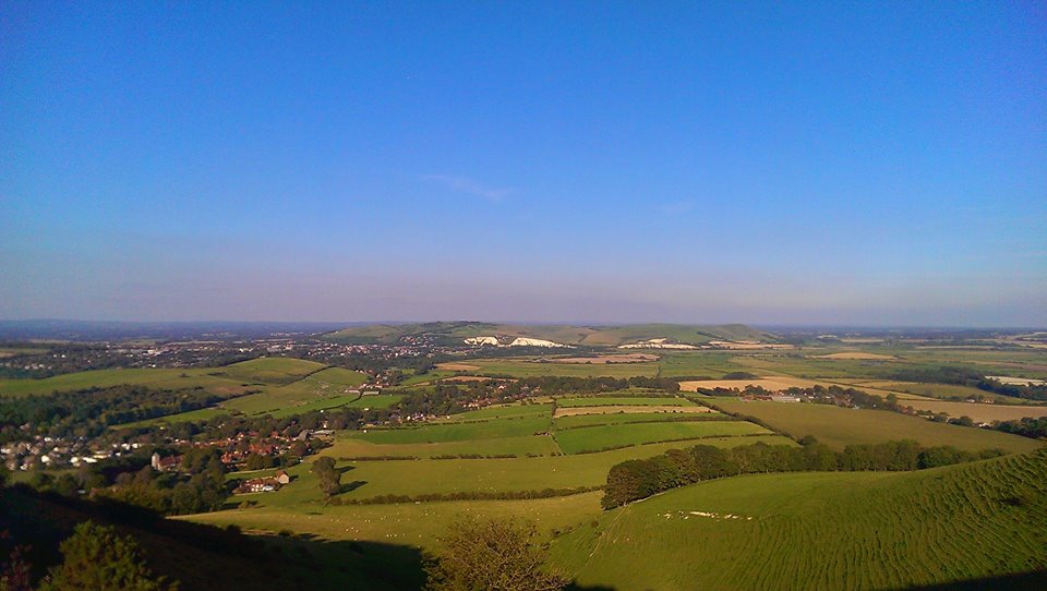
Follow the wide track straight ahead, which will start to go uphill. On your right is another valley that glories in the name of Stump Bottom, but pay it no mind. It does no good to encourage that sort of behaviour. At the top of the hill, cross a cattle grid and go straight on. You are now at the top of a shoulder of Swanborough Hill and all of East Sussex is laid out at your feet. The village of Kingston Near Lewes is at the foot of the hill. Dead ahead are the Lewes Downs, with the round, bald head of Mount Caburn at the southern extreme. The white cliffs are, imaginatively, called Cliffe, and the town to the left is Lewes, with its castle visible on its hill. I usually stop here for a roll up and a Double Decker and often find it hard to drag myself away from this view, which I regard as the finest in Sussex, even if you can see Kent in the distance. Try to ignore that misfortune.
Breach Road
Leading down in front of you are two paths. One leads to the left and, very steeply, drops down to Kingston. You can go that way if you like. There’s a pub and everything. But it’s cheating, so I’m not going to describe it, so there. Take the right-hand fork, leading down and round a spur of the hills. This is Breach Road and leads, eventually, down to Swanborough, becoming metalled as it emerges from a small patch of trees. At the bottom of the road on your left is Swanborough Manor and the main Lewes – Newhaven road. Cross this carefully – it’s busy and fast here – and through a gate into wheat fields, the flat Ouse Valley suddenly around you. Take a moment as you cross this plain to look back at the hills you’ve just crossed.
Lewes Downs and the Ouse Valley
You will quickly come to a t-junction of paths in the middle of the field. Turn left and follow the path across the fields. There is a small airstrip to your right. At the end of the field, the path goes through a gate and down some steps to a tarmac lane. It may well be completely surrounded by tall nettles, but you can get through. Turn right onto the lane and almost immediately left, just before the gates to a sewage works up along and almost within a hedgerow.
Within a Hedgerow
At the end of this path you will come back out into a wide open crop field with the path obvious ahead of you. Cross the field and the next until you almost reach the road, then turn right with a large drainage dyke on your left, lined with tall trees and sports fields beyond. Follow the dyke (there’ll probably be swans and all that sort of caper) and at its end, turn left through a gate, across the end of a mown stretch of grass and through another gate onto a tarmac road. Turn right here and then left through a bridge under the A27. Follow the road round to the right, then turn left at the first junction. Follow this road under a low railway bridge and up to Southover High Street.
To get to Lewes railway station, turn right and left at the second mini-roundabout, but take my advice and explore Lewes and its many pubs, if you have time.

 The River Arun in West Sussex is crossed by several ancient bridges, including Greatham Bridge near Coldwaltham, which was originally built in the 13th Century, rebuilt in the 18th, adapted with a new span in the 19th and restored in the 21st.