Now, I don’t know how you spend your evenings, but I spend quite a lot of mine looking at Ordnance Survey maps. Mostly, of course, I’m looking for places with rude names (Wellcombe Bottom being a particular favourite), but also I’m looking for places that might be nice for a walk. One such place is an area of open access woodland I noticed to the north of Fittleworth in West Sussex (Fittleworth of course is not a rude name, exactly, but it’s still an awesome one). Today being a nice day, I decided to go and have a look… And found this! Built as a church and a school in 1880, it stopped being used for education in 1925 and for worship in 1959.
Just the other side of the Downs from Brighton is a path that winds up the steep, northerly slopes called Burnhouse Bostall. For thousands of years shepherds lead their flocks up and down from the Weald to the Downs and back, carving these deep paths into the chalk as they went. Now the sheep are no longer driven up these paths, it is left to the rain and the boots of walkers to carry the job on.
The path fell steeply away at my feet as I entered Darwell Wood and I was quickly deep in the quiet, dreaming woodland. I could see on the map that I wasn’t far from the reservoir, but I couldn’t see it. My heart sank a little and I wondered if it would be the same as Weir Wood Reservoir, where only the barest glimpses of the water can be caught from the path and a high fence prevents getting any nearer. The path brought me to the long, gently winding incongruous sight of a covered conveyor belt, running through the trees: there are gypsum mines in these woods and the conveyor stretches for just under 5km between them. Turning away, the footpath drops once again and suddenly, to my delight, I could see the water through the trees. Fighting my way through dense willows, I emerged on the shore. What a beautiful place. I didn’t want to leave, but leave I did and looped back round through the woods to the car.
Ashdown Forest is a former hunting preserve in East Sussex and is now one of the largest areas of open access land in the South East of England. More open heath, riven with winding streams than dense woodland, the “forest” part of its name refers to its status as a hunting ground, from the original Norman French meaning of the word. Having said that, it does have woodland and that’s where I mostly was today.
Bewl Water is the largest body of water in the South East of England. A reservoir, it straddles the border between Kent and East Sussex. In the interests of safety, I stayed out of Kent. You can’t trust them there.
Now, try not to get too excited, but we’re back at that exceptional beauty spot The Downs Hotel in Woodingdean (served, excitingly, by both the No. 22 and the No. 2). I know it’s tempting, but try to resist its obvious charms. There’s a Tesco Express at the petrol station as well as a Co-op just over the junction, but if you can tear yourself away, turn left at the Downs Hotel and walk up the hill on Falmer Road. Just past the end of the buildings on the right is a small car park with a couple of tracks leading from it. The left-hand track is Drove Avenue, which becomes Jugg’s Road and is a popular and straightforward route to Lewes, but not a patch on my route (obviously), which goes through Castle Hill National Nature Reserve and has some of the best dip-slope/dry valley scenery on the South Downs.
Take the Left Hand Fork
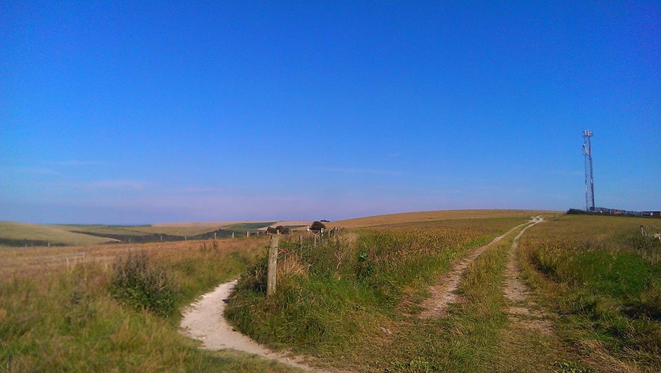
Follow the right-hand track, which I am sure you’ll be thrilled to know is called Norton Drive. Ahead of you, you will see a radio mast (you will also see, away to its left, another radio mast on the top of Newmarket Hill. So long as you’re heading initially towards the right hand of the two, you are going the right way. Well done!). Just before the radio mast, take the left-hand fork, with the fence on your right. This path, I have decided, is one of the most beautiful on the South Downs and I shall brook no argument on the matter. To your left is Newmarket Bottom and Bullock Hill rises on your right.
Follow the path all the way down and round to the right, round the end of Standean Bottom and back along the other side of the dry valley.
Have we talked about dry valleys? Let’s talk about dry valleys. The most famous dry valley on the South Downs is Devil’s Dyke and I’ll do a Devil’s Dyke walk at some point I’m sure, but the important thing is that they were all created in the same way, some 10,000 years ago, at the end of the last Glacial Maximum (or ice age, if you’re not being a ponce about these things, although technically, as there’s ice at the poles, we’re still in an ice age, but whatever). The Downs were not covered by glaciers (they only came as far south as North Finchley Tube Station), but they were frozen solid (There’s more on this guff in my post giving an exciting geological history of the Downs). As the tundra melted, the melt-water formed rivers in the dips and depressions on the Downs and eventually wore valleys into the surface of the chalk. Once the ground had all thawed, the water ran out and the rivers disappeared, leaving dry valleys behind. So now you know all about dry valleys. You’re welcome.
Barns
Anyhoo, you will now be walking along a track shaded by a slightly incongruous row of enormous London Plane trees. Be careful on this path, there are badger setts, some of the entrances to which are right in the middle of the path and perfect for unwary walkers to fall down. At the end of this path under a few big Ash trees, you will come to a junction of tracks, where you turn left, heading towards a collection of red-brick barns lacking somewhat in the roof department. Try as I might I have never been able to take a decent picture of them, but there’s always a certain glorious melancholy about ruined buildings, isn’t there? One day I will be there under the perfect conditions to take a picture that will capture that brooding melancholy of the abandoned… but I digress. Again. Sorry.
Just past the barns, turn right, go through a gate with a fence on your right, turn right at the end of the fence and then you should see a path leading off to your left along the length of this cultivated field. Through a gate at the other end of the field, across another fairly small field and through another gate into a much bigger field. Follow the path straight on and round to the right. This field may well be full of moo cows, but don’t worry, they’re friendly moo cows and used to walkers. Do keep dogs on a short lead, though. You are now in Balsdean Bottom, which is a great name for a bottom, I’m sure you’ll agree.
At the other end of this field you are presented with an exciting choice of gates, a new wooden one and and old, metal one. I like to go through the metal one, because I’m sentimental like that, but I shan’t be cross if you choose the wooden one, although I will silently judge you.
View from Swanborough Hill
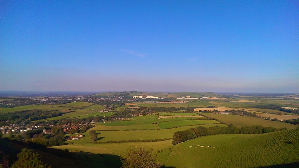
Follow the wide track straight ahead, which will start to go uphill. On your right is another valley that glories in the name of Stump Bottom, but pay it no mind. It does no good to encourage that sort of behaviour. At the top of the hill, cross a cattle grid and go straight on. You are now at the top of a shoulder of Swanborough Hill and all of East Sussex is laid out at your feet. The village of Kingston Near Lewes is at the foot of the hill. Dead ahead are the Lewes Downs, with the round, bald head of Mount Caburn at the southern extreme. The white cliffs are, imaginatively, called Cliffe, and the town to the left is Lewes, with its castle visible on its hill. I usually stop here for a roll up and a Double Decker and often find it hard to drag myself away from this view, which I regard as the finest in Sussex, even if you can see Kent in the distance. Try to ignore that misfortune.
Breach Road
Leading down in front of you are two paths. One leads to the left and, very steeply, drops down to Kingston. You can go that way if you like. There’s a pub and everything. But it’s cheating, so I’m not going to describe it, so there. Take the right-hand fork, leading down and round a spur of the hills. This is Breach Road and leads, eventually, down to Swanborough, becoming metalled as it emerges from a small patch of trees. At the bottom of the road on your left is Swanborough Manor and the main Lewes – Newhaven road. Cross this carefully – it’s busy and fast here – and through a gate into wheat fields, the flat Ouse Valley suddenly around you. Take a moment as you cross this plain to look back at the hills you’ve just crossed.
Lewes Downs and the Ouse Valley
You will quickly come to a t-junction of paths in the middle of the field. Turn left and follow the path across the fields. There is a small airstrip to your right. At the end of the field, the path goes through a gate and down some steps to a tarmac lane. It may well be completely surrounded by tall nettles, but you can get through. Turn right onto the lane and almost immediately left, just before the gates to a sewage works up along and almost within a hedgerow.
Within a Hedgerow
At the end of this path you will come back out into a wide open crop field with the path obvious ahead of you. Cross the field and the next until you almost reach the road, then turn right with a large drainage dyke on your left, lined with tall trees and sports fields beyond. Follow the dyke (there’ll probably be swans and all that sort of caper) and at its end, turn left through a gate, across the end of a mown stretch of grass and through another gate onto a tarmac road. Turn right here and then left through a bridge under the A27. Follow the road round to the right, then turn left at the first junction. Follow this road under a low railway bridge and up to Southover High Street.
To get to Lewes railway station, turn right and left at the second mini-roundabout, but take my advice and explore Lewes and its many pubs, if you have time.
I remember once *begins filling pipe-bowl with tobacco* when I was walking on the Cheviots in 2008, I think it was. *packs tobacco down with thumb*. It had snowed heavily for a few days before and the snow was about six feet thick on the tops *puts pipe in mouth* *takes pipe back out of mouth* but on that day, you see, on that day it was beautiful weather. Not a cloud in the sky. Quite stunning, in many ways. *puts pipe back in again* *lights pipe*. Now then *accidentally inhales too much and brings up a lung* the top of the snow *wipes eyes* had frozen into a crust, so if you were careful, you could walk on the top, but if you trod too heavily, you’d go straight through. *goes to put pipe back in mouth, but thinks of something else to say first*
Of course, on the Cheviots *jabs mouth of pipe at the reader for emphasis* the top is blanketed. Blanketed, mark you, with peat bogs, up to six feet deep. Well, you can only imagine what it would be like if you fell through. *puts pipe back in, leans back in wing-backed armchair and puffs contentedly* I fell through, of course.
Fortunately I had a stick I had cut from the hazel coppice at Easton Farm Park and finished with a piece of red deer antler, which stopped me going all the way in. I was halfway up a short, steep hill, some miles from the nearest road. Not another soul had I seen all day, as I walked on the crisp, clean snow beneath bright, sparkling skies of purest blue, light wisps of cloud just gathering about the top of The Cheviot itself behind me – Scotland to my left and England to my right. The right leg went in first, followed swiftly by its companion, leaving me dangling off my stick and praying fervently that I had put the antler on properly, as the integrity of that joint was all that now prevented me from reaching an icy grave that day.
Some pile of rocks or other
I don’t quite know, now, how I did it, but I suppose the adrenaline starts to pump in moments like those and, after a few moments contemplation of my predicament, I suddenly found hitherto untapped reserves of strength, hauled myself out and continued on my way.
*taps pipe out into ashtray*
When I got back into town that evening, all the B&Bs were closed, because the weather was so bad, so I had to check into quite a posh hotel. I chatted up the manager a bit, who I’m pretty sure was Bowling from the Pavilion End, if you know what I mean, and got upgraded to their best suite, with an enormous bed and beautiful bathroom. I bathed in luxury before descending for dinner in an almost deserted restaurant.