
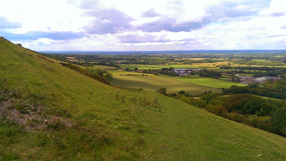
1. Bostalls

In the steep hillsides above Fulking there lie deep scars, criss-crossing the landscape. The V-shaped depressions known as bostalls are a familiar sight all along the Downs and on Fulking Escarpment in West Sussex there is a particularly spectacular collection of them, which between them tell a story of the long history of the Downs. When people first came back to what would eventually become Sussex after the end of the last Ice Age, they started clearing the forests on the top of the Downs and using them to graze sheep. Starting around 6 thousand years ago, the Downs were almost totally cleared by around 2000 BC and sheep have been grazed there ever since – reaching a peak in the 17th Century. Alongside this grazing, arable farming also grew up in Sussex. The clays of the Weald are too heavy and waterlogged to be easily cultivated, even with iron ploughs and the soils on top of the Downs were too thin and alkaline to be of any use to those early farmers. But along the bottom of the Downs, where the chalk and the clay meets and mingles, the soil is lighter and it is possible to plant crops there. To help fertilise the fields, the sheep grazing on the Downs during the day would be lead down to the arable land to spend the night, where their droppings would improve the soil. The soil of the Downs being very thin, it quickly wears away under the feet of thousands of sheep allowing rain water to run across the surface of the chalk beneath, which soon erodes to form the deep tracks we see and still walk today – some of them a thousand years old.
2. Lynchets
More evidence of early farming activity on the Downs can be seen in the form of lynchets (sometimes known as strip lynchets), particularly around some of the dry valleys of the dip slope (the more gentle southerly slope of the Downs running down towards the sea). These long linear features were formed when old ploughs turned the soil, which then crept slowly down the hill, forming shelf-like platforms. Opinion is divided as to whether this was simply a side-effect of old-style ploughs – which turned soil only one way – or a deliberate act intended to better retain water on the hillsides and to provide flat terraces to be more easily worked.
3. Terracettes

In some ways like a smaller cousin of the lynchets, terracettes, despite sounding like a 60s backing group (In fact, I’m thinking of starting a band called Strip Lynchet and the Terracettes, but that’s for another article), are in fact long step-like formations on the steeper parts of the scarps of the Downs, created as a result of soil-creep and the action of grazing animals walking across the face of the hillsides. The poor, crumbly soil of the Downs (called a rendzina soil) easily washes down the hill, but collects around the base of the grass, which in turn provide a foothold for the wandering cattle and sheep. As they tend to walk along the face of the Downs, rather than directly up and down the steep slopes, they soon walk the soil into the form of terracettes.
4. Chalk Pits

While wildlife across most of the Downs is adapted to surviving in extremely exposed situations, the numerous chalk pits provide some shelter and a range of ecological niches that would otherwise not be seen. Chalk was dug out of these pits before being baked in kilns to produce lime. The lime would then be taken into the fields below and ploughed in – both to address creeping acidification of the soil and in an attempt to make the heavier clays light enough to plough. Once a chalk pit had been abandoned, it often became a haven for wildlife, giving shelter for more delicate species and allowing scrub woodland to grow up (an unfamiliar sight on the Downs before the latter half of the 20th century), providing yet more habitats to be filled with life.
5. Dew Ponds

Since at least Saxon times and possibly much earlier, people have got round the lack of natural water on the Downs by constructing dew ponds. The chalk being highly porous, rain water quickly soaks away, leaving nothing for sheep to drink. In order to catch and retain rainwater, these perfectly circular, saucer-shaped ponds were dug, lined with chalk and puddled clay and left to collect their essential bounty. Like the chalk pits, these man-made features provide habitats that would otherwise not be available on the Downs. Some of the better-maintained ponds even have great-crested newts in them, despite being some distance from the next nearest stretch of water.
6. Hangers
Less common in the eastern part of the Downs, steep, wooded hillsides known as hangers proliferate as you go further west towards the Hampshire Downs. Studded with enormous, beautiful beech trees, these woodlands also contain a great deal of ash, which grows like a weed on the Downs and some of the oldest, coppiced trees of the area – small-leaved lime trees, remnants of the original forests that once covered the hills, before the coming of people and their sheep. In other parts, shepherds planted areas of coppiced hazel to provide wood for making their hurdles to control and pen the sheep during shearing.
7. Coombes
Some of the steepest slopes on the Downs are found at the top of these deep, bowl-headed dry valleys. The terracette-lined slopes were carved out by melting water at the end of the last ice-age and now provide some of the best-preserved stretches of calcareous grassland in the area, as it was impossible to plough up and “improve” them – in comparison to the flatter areas on the dip slope that were lost forever under arable fields in the 1940s, when the pressures of war required a great effort to produce more food from the landscape – made possible by modern ploughs and fertilisers. These unimproved tracts of grass, therefore, provide habitats for some of the rarest plants in the UK.
8. Bottoms

Where the coombes widen out, the soil washed down from the steeper hills collects, to form deep, easily-worked and fertile soils and it was here that some of the earliest farming communities formed when humans came back to Sussex after the ice receded and the tundra which covered the Downs thawed. The Beaker People lived here before the coming of the Iron Age and the Celts, but ultimately the lack of natural water in the bottoms forced people down into the Weald, where drinkable water emerges from under the Downs and flows into the rivers.
9. Archaeology

The Downs have always enjoyed a strategic importance in the wider landscape giving, as they do, commanding views over the Weald. It was a powerful person who could claim control of the Downs and in prehistory they built hill forts, with gleaming-white chalk embankments that could be seen from miles away, proving that power. Long ditches known as Cross Dykes were dug to delineate borders between properties and the dead were venerated with tumuli (burial mounds) that stud the hilltops to this day.
10. Downs
Named from the Saxon word “dûn”, which also gives us the modern word “dune”, the whale-backed rolling hills of the Downs are one of the last bastions of calcareous grassland in the UK and, indeed, in Europe. The long history of grazing on the Downs and folding the sheep on the fields below at night stripped nutrients from the poor soils, while the constant nibbling of the sheep prevented larger plants from growing. This created a unique habitat that is one of the most biodiverse in Europe. An astonishing variety of flowering herbs and rare grasses supports populations of insects from ants, whose hills cover the slopes of some Downs in great profusion to beautiful blue butterflies on the sunnier elevations and the green woodpeckers and skylarks that live on the insects. With the coming of cheap lamb from New Zealand, grazing has declined on the Downs and this unique landscape is under threat from increasing scrub woodland, destroying the herb-rich grassland. Now that the South Downs have been declared a national park, this degradation can, hopefully, be arrested, but we will never see again the Downs as they were before the coming of the plough and the ash, hawthorn and sycamore scrub that has killed some of the rarer plants forever.

This is really interesting. I will need to come back to read it all carefully. Some of the information you have here does not appear to be available elsewhere and so I wonder if you have sources that you could share? I am particularly interested, for example, in when the Downs were cleared of trees.
LikeLike
Hi Gavin, glad you enjoyed the post. My main source for a lot of the information, including the dating of clearances, is The History of the Countryside by Oliver Rackham (1986). If you’re a fan of careful reading on this subject then I can recommend no other book more highly!
LikeLiked by 1 person
I will have to source a copy…. And reread this post!
LikeLike