Designs in Adversity: Architecture and Society in an earlier Age of Pandemics

Endless pages, of course, have been written on the development of Gothic architecture in England, but today I am writing in the midst of the Covid-19 epidemic, which has brought to mind the ways in which societies express themselves through the buildings they erect and so I thought: “Why not?” If you’re not seeing the link between the crisis that currently engulfs us and old churches and castles… hopefully you will soon.

The various stages through which Gothic architecture proceeded in medieval England tell us a huge amount about how society itself was developing during the period. The very term “Gothic” itself starts us off, although no-one in the medieval period ever called it “Gothic”. As with so much to do with how we view the past the name was first applied to “buildings with pointy arches” in the 19th Century and means, simply, “Eastern”. There is some conjecture that the structural benefits of the pointed arch, as opposed to the semi-circular “Romanesque” arch then employed in Europe, may have first come to the attentions of Westerners during the Crusades. Islamic architects certainly understood that pointed arches spread the weight of the wall above more effectively than semi-circles, but whether passing, marauding, Christian hordes took much time to stop and appreciate oriental building techniques has never been proven. Nevertheless, the very fact that this knowledge spread throughout Europe tells us one thing: that people were travelling further and exchanging ideas with a greater variety of people.

Ever since the fall of the Western Roman Empire in AD476, a great regression in building ability had occurred across Europe. Old Roman buildings were left to fall into decay and in England the invading Anglo Saxons preferred to build their towns and villages away from the old, ghost-filled ruins of Roman Britannia – although they made good use of their roads. Many old buildings were plundered for their stone and, it seems, not a huge amount regarding construction was learnt – at least early on.

In the end, the tricks of the Romans were rediscovered. Greater mobility and larger, richer kingdoms in England led to more interaction with their continental counterparts. Christianity was brought back by St Augustine and churches began to be built. Many of these directly aped Roman designs. Even the earlier Saxon buildings combined elements re-learnt from Roman times: although their smaller windows often had triangular arches over them, the double window of two semi-circular arches next to each other, with a turned pillar between them, was often a feature, especially on higher-status buildings – a feature taken straight from the Classical world.

As time went on, Romanesque buildings grew to achieve great size and splendour, but their reliance on semi-circles for support brought problems. To build a tall structure, the walls had to be very thick, or the weight would bring it crashing down. Any windows or doors had to be small, pillars and columns had to be enormous and there was a definite limit on how wide a room could be before a semi-circular, or “barrel”, vault would collapse under its own weight.

But then, in just the same way that Romanesque ideas had spread to England from abroad, so came newer ideas. The pointed arch had, in fact, been seen quite commonly before in England, but almost always as a purely decorative feature – often where semi-circular arches had been overlaid on top of each other to create designs to ornament walls, as seen here at Ely Cathedral.

© Steven Zucker

But then, in the year 1135, or thereabouts, something seismic happened in the northern English town of Durham. A great, Norman (as the Romanesque is often known in England) cathedral was being built, but when it came to the roof, for the first time, pointed arches were used to throw a stone vault across the wide nave. Rather than purely existing for decoration, these arches were structural – and their influence was enormous.

Durham cathedral is not the first Gothic cathedral in Europe – that distinction belongs to the Basilica St Denis in France. Indeed, Durham cathedral is not really a gothic building at all. It is very much Romanesque. Its walls are thick, its columns massive and its windows small. Decoration consists of zig-zag, and dogtooth designs. The overall effect could be called gloomy, or heavy, although certainly impressive…

The rose window at the east end is a later addition. Note how only the ceiling has pointed arches – all the others are semi-circular © Oliver Bonjoch

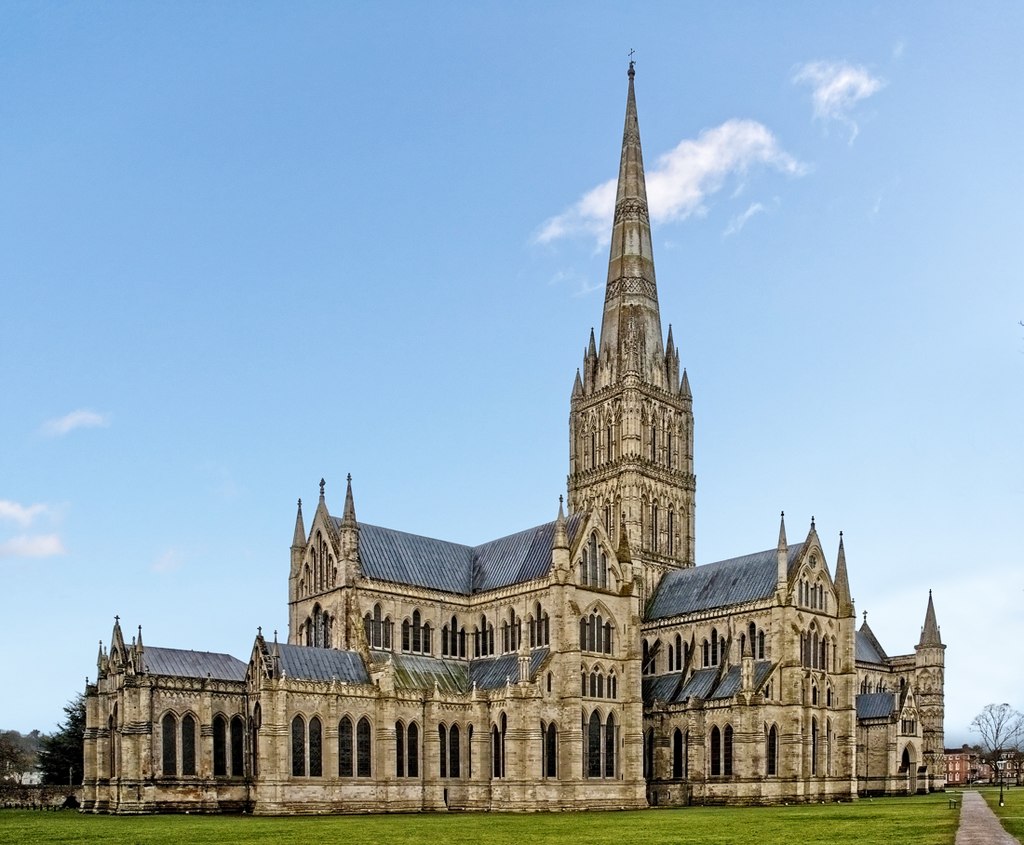
This discovery – that pointed arches are stronger arches – soon came to be used much more extensively and a style developed in England that we know, inventively enough, as Early English. In fact, it’s a bit off to try to claim it as a purely English invention – the style had been in use in France for some time before we got in on the act – so a more tactful name for it is “Lancelot”, from the shape of the windows. Designers had realised that, by using pointed arches for strength, openings (windows and doors) could be much larger. Windows became wider, columns and piers narrower, walls loftier and what had once been dark, foreboding church buildings became light and elegant. By far the greatest example of this style in England is to be found at Salisbury – a most unusual cathedral in that the main bulk of it was built within a mere forty years, which gives it a highly unusual overall conformity in design. A truly beautiful building, only the tower, spire and cloisters were added later.

Tall and narrow “Lancelot” windows are grouped together to give the impression of larger windows. © Diliff
The interior effect is simple, light and elegant © Diliff

Not only did these new, lighter, airier churches reflect new building techniques; they also showed a new relationship with religion in this period. In the 13th Century people were moving away from the almost other-worldly mystery of the Romanesque period and were finding a new, exultant expression towards God in their buildings. They soar towards the heavens, their tall pointed windows showing the way up to the skies, where the Lord himself was, surely, looking benevolently down on these new, glorious works completed in His name. The people looked upon their beauty and glory and rejoiced.

That wasn’t all when it came to technical innovation, though. Take another look at the exterior of Salisbury and you will see that the windows are grouped together to give the impression of larger windows. Some of them even have a decorative arch over the top. There are groups of three and even five windows together. You can feel the architect yearning to make even bigger, wider windows.

Well, as it turns out, it wasn’t all that complicated. The masons who built Salisbury were almost there. Someone, it appears, must have reasoned that if they could put an arch over all five windows, then maybe that arch could actually be made structural and would be strong enough to support the wall above it. The thin sections of wall between these Lancelot windows could then be reduced to become mullions. If they weren’t needed to hold up the weight of the wall above, then all they had to hold up was glass, so they could be much thinner and part of the design of the window itself, rather than structurally integral to the building.

And if you were grouping lances together, then that left a diamond-shaped area between their pointed tops and the wall-supporting arch above… perhaps a circular opening could be fitted in there? And then… even the areas left by those could be filled in with glass too?

It took a little while – these things mostly happened by evolution, rather than in sudden leaps – but from these thoughts the Decorated period was born.

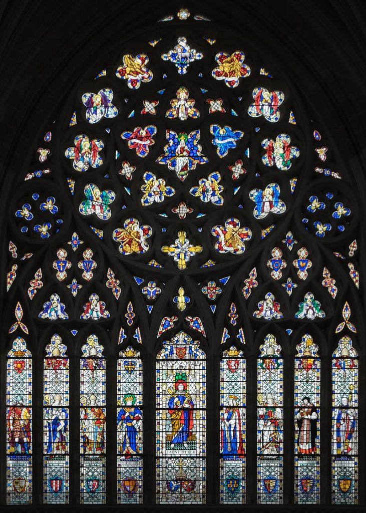
Firstly, slightly cautiously, the designs of this new period were based on good, strong shapes. Despite the fact that the pointed arch of the whole window was taking the weight, the masons still couldn’t quite bring themselves to leave strength in the shapes they used behind, so circles were employed between the lances where possible. This, initial stage of the Decorated is known as the “Geometric Decorated” and a wonderful example can be seen in the West Window at Exeter

The Great West Window at Exeter © DeFacto

This new, richly ornamental style produced an explosion in inventiveness and it wasn’t too long before people realised that it didn’t matter what shapes you used under the arch – the arch was strong enough on its own. New, extraordinary designs were produced that celebrated nature. The mullions of windows could be extended upwards, above the lances and then split and cross in an exuberant, joyful display that gloried in the Good Lord’s creation. For a period of about fifty years in the first half of the 14th Century the Gothic reached its poetic zenith in England in the Flowing Decorated period.

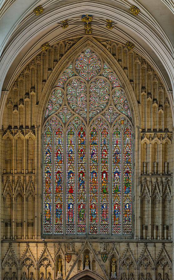
The two greatest windows of the style were constructed at York and Carlisle, while extra adornments and fiddly bits were added to ceiling vaults in the form of lierne ribs that served no structural purpose, but were purely for decoration, as in the Lady Chapel at Ely. At Southwell Minster the most incredible carvings of leaves were added to the portal to the chapter house. The overall effect is one of excitement, exultation and joy in all that was good in the world.

Carlisle’s East Window is the largest Flowing Decorated window, with a design based on tulips © Diliff
The Great West Window at York Minster, known as the Heart of Yorkshire © Diliff
Decorative lierne vaulting in the ceiling of Ely’s Lady Chapel © Diliff
Extraordinarily delicate naturalistic carving at Southwell Minster © Kognos

But then. Disaster. In June of the year 1348 the Black Death arrived in England. The beautiful, joyful window at Carlisle was unfinished and remained so until the 19th Century, when some of its interior stonework was finally completed. This great work of joy at God’s great creation was cut short – its masons dead of the plague. The exultant Decorated period was over.

Huge numbers of people died in wave after wave of plague. What had been the societal norm of joy and exultation became fear and trepidation. How could so many have died unless God was angry with his people? Surely they must have been living in very great sin for Him to visit such destruction upon them? The Black Death wrought huge changes on society and this was reflected in the style of their churches. Gone were the flowing, nature-based designs and in came vast, terrifying cages based on straight lines. The Perpendicular was born.

The Choir of Gloucester Cathedral © Diliff

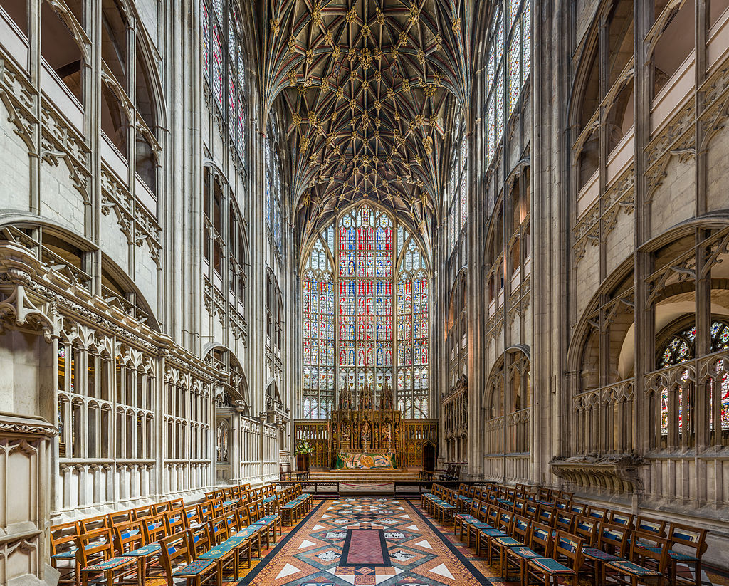
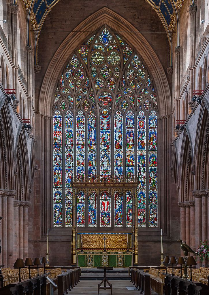
The choir at Gloucester Cathedral is, in fact, in its bones, Norman, not Perpendicular. Look at the arches of the arcade and gallery in the walls. No points here. But the whole has been overlaid with stone tracery produced in the Perpendicular style – with strong emphasis on horizontal lines. And then there’s the East Window itself. There’s no doubt that this is Gothic, with its vast pointed arch over the whole. It is the largest pre-modern window anywhere in the world – the size of a tennis court. It is enormous, but there’s none of the delicate, curvilinear tracery of Carlisle or York. This is a window designed to inspire fear and awe. Your God is powerful and you disobey him at your peril. Society had become all too aware of this, now that so many of their compatriots lay mouldering in their graves.

And just look at the vault! This is the period where ceiling vaults really took over as the main decorative features in cathedrals. Partly this is a result of practical necessity. The Black Death had carried away a great many skilled masons and lierne vaults could be mass-produced in much simpler designs than those required by Decorated Period windows. Enormously elaborate designs were created from standard-sized ribs producing, in this case, a vision of the very starry firmament itself! Look upon your God and fear Him!

***

But it was also at Gloucester… some time after the great shock of the plague had subsided… that some of the most beautiful works of the final stage of the Gothic period were wrought. Fan vaulting allowed a little exuberance and joy back into architecture, before the Reformation changed everything. And fans of the Harry Potter films will recognise them too…

Fan vaulting in the cloisters at Gloucester Cathedral © Christopher JT Cherrington

And then… along came the Reformation. The new Protestant religion emphasised one’s personal relationship with God. Great men no longer displayed their wealth (or bought favours from the Pope) by building wonderful churches and cathedrals. All they needed was prayer to avoid an eternity in Hell. They turned their attention away from building to the Glory of God and towards the Glory of their Purses. The great English Country House was born and the Gothic faded away behind them as the Tudor Period found new styles more suitable for the houses of the great and good.

Firle Beacon

Some particularly good pictures of clouds in this set. I walked in a great big loop from the car park at the top of Firle Bostal, over the Beacon itself, down to Stump Bottom (hehehe) and back up through Blackcap Farm.

IMG_8020
IMG_8031
IMG_8033
IMG_8037
IMG_8039
IMG_8040
IMG_8042
IMG_8044
IMG_8045
IMG_8046
IMG_8050
IMG_8055
IMG_8056
IMG_8057
IMG_8058
IMG_8059
IMG_8068
IMG_8069

Brede High Wood

Brede High Wood is one of those places I’ve been driving past for years, always thinking “I should stop and have a look one day” and, eventually, on the 13th of September 2018: that day came. An almost magically beautiful woodland owned by the Woodland Trust a patchwork of ancient areas, old coppice, plantations and the occasional open glade, I was entranced by mysterious fungi, wild hops, portentous arches and mile after mile of beautiful, stately beech. Very glad I finally decided to stop and look around.

IMG_7902IMG_7903IMG_7905IMG_7907IMG_7909IMG_7910IMG_7912IMG_7913IMG_7914IMG_7915IMG_7916IMG_7918IMG_7921IMG_7922IMG_7926IMG_7927IMG_7928IMG_7931IMG_7932

Wivelsfield – Burgess Hill. 12.55km (7.8 miles) Approx 4 hours

hedgetreesclouds

Hey! Hoi! Hupla! It is Spring! There are bluebells! It has, therefore, become essential to set forth on a jolly stroll so as to look at them. Now, my original plan had been to do my usual walk from Burgess Hill to Plumpton via Blackbrook Wood, but the good conductors of Southern Rail had other ideas and went on strike, rendering Plumpton Station inaccessible by train. Due to this unexpected happenstance, I was forced to change my intended route and settled on starting at Wivelsfield and ending at Burgess Hill, this route taking one also through West Wood on the way to Blackbrook Wood. I had never been to West Wood before and it turns out to be lovely and if it hadn’t been for the striking train conductors, I would never have found it, which just goes to show that collective organisation of the labour force has benefits throughout society.

Now then. First of all let’s get over any sniggering you may wish to do at the name “Wivelsfield”, no I’m not sure what a wivel is either, nor why one might want them felt, but let’s move on. Upon exiting the station, turn right on Leylands Road, if you’ve come from the Brighton direction, you will pass under the railway. Those coming from the Far North, like Haywards Heath or somewhere, will not get to experience this joy. Or at least, I suppose you could just pop through the bridge and back again if you really want to, but I’m not sure why you would if I’m honest. It’s a just a bog-standard railway bridge and wholly unremarkable. Proceed to the big junction you can see ahead of you and turn left onto Valebridge Road. After a little while there is a signed footpath on the right – the first that you will encounter. Follow this between the houses and straight ahead where it crosses a road until you cross a stile and into a meadow.

The path then heads slightly off to the left and is easy to follow. At the other side of the field, you pass through a gap in the hedge and then along the side of the next field with a hedge on a bank to your left, when I was there it was smothered with bluebells and stitchwort, which was rather lovely of it. We know how to tell the difference between English bluebells and Spanish ones, right? The flowers of English bluebells are all on on side of the stalk, making it bend over at the top in a charming fashion, while the brazen Spanish ones have flowers on all sides and, thus, stand upright in a most unseemly way. I mean, it’s not their fault they don’t know how to behave. Despite this obvious poor behaviour, they are beginning in places to out-compete and widely hybridize with their English compatriots and how you tell them apart I couldn’t venture to say. You’re probably best off throwing your copy of the Wild Flower Key at it and running off screaming.

Follow the path ahead which becomes a private road past Ote Hall, which is written in that fancy writing on the map that means it’s well old and posh and stuff. Where the road turns to the right, you will see a footpath straight ahead, which you should eschew, favouring instead one that turns half right and goes over a stile or through a gate or something, the path then sticking to the edge of the field on your right, marked by a hedge.

Now, I think we’ve come to that stage in life where we really need to have a little chat about hedges. In the old days, before my old Dad was born even, fences were a very uncommon sight on farms. “But how”, I hear you cry, aghast. “How did they control the livestock? Were the cattle and sheep running hither and yon, rubbing shoulders with the horses and causing mischief in the barley fields?” Why no, they were not. They were kept in place by hedges. Now, I don’t know if you’ve seen a cow, but I’m guessing you probably have. Big things, cows, as I’m sure you will agree. Hefty heifers and, erm, bulky bullocks. “How”, you may be given to wonder, “did the often spindly, gappy-looking hedges one sees about the place ever stop half a ton of beef from going anywhere?”.

The answer lies in the amount of labour available on the fields before the advent of mechanisation. Farms could often support dozens of workers in various roles and, during the winter when there was less to do on the arable fields, the hedges would be laid. The stems of the hedge plants would be partially sliced away on one side and then the whole plant pushed over to about a 45 degree angle. Hazel stakes cut from the woods would be hammered in upright along the length of and inside the hedge and the cut plants weaved through the posts, the tops of which would be bound with plaited thin hazel or willow withies. This created a hedge much thicker and stronger than one left to its own devices. Strong enough, even, to give a bull second thoughts – and bulls are fairly unlikely to have first thoughts, let alone second ones.

This thick hedge not only stopped beasts of the field from scattering willy nilly about the countryside; they also provided habitat for birdies and small mammals and wild flowers grew along their edges. They often linked areas of woodland, giving a corridor for wildlife to move across the landscape out of sight of predators, such as barn owls. Between the wars, however, the tractor and combine harvester came to farming and the workers weren’t needed. Huge farms could, for the first time, be run by a mere handful of people. A tractor with a mechanical augur on the back can drill holes in the ground and put a fence up in no time. No-one laid hedges any more and all the wildlife that depended on them is ebbing away from the countryside.

But what’s the difference between a hedge and a hedgerow? More on that later.

At the end of the field, the path goes around the right-hand end of Great Otehall Wood and then left with the wood on your left. You should now be in a long narrow field and the path leads diagonally across it to a footbridge over a stream. Cross the stream and follow the path ahead until you reach a road, which you head more or less straight across, the footpath slightly to the left of the one you’ve just left and obvious, leading down beside and fenced off from the grounds of a house, you will soon enter a scrubby bit of woodland. Of no great age for the most part, there is some older hornbeam coppice dotted about and a few older oaks that show every sign of growing in an open aspect, rather than in a woodland. Large trees that have grown in woodland tend to grow tall and straight to reach the sun, while those grown in the open are often shorter, but their branches spread out from much nearer to the ground, creating more of a domed shape. Turn left.

At the end of the wood, the path becomes a road in front of some beautiful old cottages. I had intended to take the second path on the right into West Wood, but I got a bit over-excited and turned right too soon at the first footpath and found myself in a field, so turned left there and followed the edge of the field until I went over a stile and onto the bridleway I had been intending to take. Turn right here, into the woods and follow it all the way through. I have no idea as to the ownership of this wood, but there were no signs saying “PRIVATE” and there were many clearly well-used paths through it, so… So long as you keep going in the same direction as the path, which follows the right-hand side of the wood you should be fine… What I will say about this wood, though, is it is truly beautiful and packed with ancient woodland indicators, as well as carpets of bluebells and anemones. Really lovely. You can find out more about how to spot ancient woodland in my post on that very subject here.

blackbluepath

At the end of the wood, you will be able to see fields through the thin band of trees you are now in to your left. Ignore a path off to your left that crosses the field, which came as something of a relief, as that path was hellishly muddy on the day I was there, and follow the path leading slightly to the right and stay in the trees. After a short while you will come to a track which you turn right onto, past houses. The track will bring you to a road, where you turn left and then immediately right and into Blackbrook Wood. There may well be cars parked at the entrance, which has a short wooden fence and a footpath sign.

Blackbrook Wood is one of my favourite woods in Sussex, bursting with ancient woodland indicators, like extensive hazel and hornbeam coppice, midland hawthorn, wild service tree, field maple, wood banks, stumped trees, lovely sinuous edges and, of course, more carpets of bluebells and anemones.

If you follow the main footpath through the wood, you will come to a gap in the woods with a gate leading into a field between Blackbrook Wood and another wood and giving a wonderful view of the Downs. Streat Hill is the highest point on the ridge that you can see. Follow the track (which is often very muddy here) on through the second wood. At the end of this track, if you turn right you are then in what is probably an assart hedgerow.

Aha. Ahahaha. Hedgerow. What’s the difference between a hedge and a hedgerow? Very simply, a hedgerow has trees in, which a hedge doesn’t. A hedge is generally a planted thing, often made up of all the same species, and tended in the way described above to make an impenetrable barrier. Hedgerows tend to be made up of many different species and include large trees. As a rule of thumb, the more woody species present in a hedgerow, the older it is. Each different species adds about a hundred years, so by counting the number of species it is possible to estimate the age of the hedgerow. In the case of assart hedgerows, though, these are remnants of older woods that have been left behind when fields have been cleared and may, therefore, constitute a thin strip of ancient woodland in their own right. This one has wonderful banks of primroses, bluebells, anemones, stitchwort and early purple orchids in the spring.

Return now back the way you came. Once you re-enter Blackbrook Wood after the gate with the view, do not on any account turn left on the first path down to a second track. Neither should you turn right along this track through more hornbeam coppice. You certainly shouldn’t follow this to a set of metal gates leading to a road, then turn right on a path that leads back into the woods and I can’t believe you’re even thinking of turning left at the end of that path and following another path back to the entrance you came into the woods by. Shame on you, this is private property and there are signs to say so.

blackblue

Once you emerge back onto the road, turn left and cross the end of Spatham Lane and follow the marked footpath on the other side. Follow the path along the right-hand side of a couple of fields and then right, through the gate on the other side, ignoring a bridleway leading off to the left of the gate. You will now be in a fenced-off path with cottages behind an apple-tree containing hedgerow on your right. Turn left over the stile after a short while and cross the large meadow, walking to the right of the trees on the middle of the field. Cross the railway line on a brick bridge and continue walking in much the same direction. The path should be discernible on the ground. There are wonderful, expansive views of the Downs here. You will end up in the corner of the field and through a metal gate onto a fairly busy road. Turn left across the front of a house and then right along a track opposite the house.

Follow the track ahead, which after some horse paddocks becomes a path through an area of fairly recently planed oak woodland and over a stile into a field, the right-hand edge of which you follow until you reach a private road, which you follow ahead. Straight over the next road and along the driveway of Weald House, just past the entrance of which you will see a stile into a field, with a water tower prominent. Climb the stile (or maybe it’s a gate, I can’t remember, but whatever) and turn left, down the hill, through the hedge, straight on across the next field, over a wooden footbridge through another hedge and over a stream, straight ahead again up the other side and you will come to the railway line, where you turn right and walk along the well-made path to Burgess Hill station.

Pevensey Levels

Pevensey & Westham – Polegate 9th June 2015

pev ditch12 miles: approx 6 hours

Navigation:

Now then. As you may have noticed, this is quite a long walk. The going is pretty easy. They’re not called “Levels” for no reason, but still. 12 miles is a long walk if you’re not used to it. Walking on the 1066 Country Walk section is very easy to follow, but after that navigation becomes much more difficult. Paths are often poorly marked, have locked gates across them that require climbing or are almost impossible to follow. An OS 1:25,000 map of the area (Eastbourne & Beachy Head) is recommended along with the ability to read it. There was a lot of head-scratching and map-scrutinising on this walk.

Farm animals and wildlife:

This walk is almost entirely across pasture and on areas not accustomed to a high density of walkers. Almost all of the fields had sheep, cattle or both, which can react badly to humans and their dogs. As well as this, much of the walk is in the habitat of a great deal of wildlife, particularly bird species, some of them endangered. The disturbance caused by people and, in particular, their dogs, can be severely detrimental to such species.

Moo cows
Moo cows

Basically, be mindful of where you walk and how loud you’re being. And don’t bring a dog.

Right. That’s the finger-wagging done, let’s get on with the walk. This was a different sort of walk for me. In terms of landscape that is – I mean, I didn’t walk sideways, or on my hands or anything. It was still quite traditional with regards to putting one foot in front of the other and everything. No, it was the flatness that made it different.

The Levels are, as the name suggests, quite level. The reason for this is that it’s all reclaimed land. Until relatively recently in geological terms, the whole area was under water, at least at high tides. Indeed, throughout the first part of the walk, you will notice that you are walking towards a line of low hills that stretch along the horizon from west to east in front of you. This is what’s known as the Saxon Shore, which may give you a bit of a clue as to what sort of time period we’re talking about.

Attempts to drain and farm the Levels appear to have started as early as the 8th Century and really got going in the Middle Ages. This was mainly achieved by the expedient of waiting for the tide to go out and building sea walls to stop it coming back in again. This seems to have worked nicely until the “Great Flood” of 1287, which as the name suggests was a flood, and a great one at that. After that time commissioners were appointed to take charge of the drainage of the Levels and this was completed by 1696.

Wind pump
Wind pump

Even before they were drained, certain higher areas never flooded, even at high tides, leaving “islands” among the waves. These islands were known as “Eyes” or “Eys” and this name persists in names such as Horse Eye Level and even Pevensey itself. Indeed, before the drainage, boats were able to moor at Pevensey Castle, which is now some distance inland. Before salt water was entirely expunged from the area, harvesting salt was an important part of the local economy.

Blimey, I’ve written a page and we haven’t even taken a single step yet. Sorry about that. I do go on.

From Pevensey & Westham station, turn right and then right again at the mini roundabout. Turn left onto Peelings Lane, past a little pond on your left. After a short while you will come to the entrance to Castle Farm on your right. At first it doesn’t seem marked, but there is a small footpath sign on a telegraph pole to the right of the entrance. Go straight through the farmyard and over a stile into a meadow. The path is pretty obvious ahead of you and goes straight through a gap in a hedge, then turns slightly to the left – heading towards a footbridge. Cross the bridge, turn right (again the path is obvious) and a few yards later enter a hedgerow where steps take you up a short rise to the edge of Sussex’s attractive A27. Now then, I’m sure you remember the Green Cross Code, but I will say BE CAREFUL. The A27 is very busy and fast, but not a dual-carriageway at this point, so crossable with care. Down steps and through a hedge on the other side and we emerge on our first proper bit of Level. Paths immediately become slightly tricky to see on the ground, but you will see a footbridge ahead of you and slightly to the right. Head towards that – over another couple after that – and you will come to a much more substantial bridge over a rather wider stretch of water. This is Pevensey Haven.

Buttercups and red clover

Now, I’m not good at bridges at the best of times, but this one is terrifying. IT BOUNCES UP AND DOWN. Don’t like it. I ventured on to take some pictures, but amidst the sweating, shaking and crying, they didn’t come out very well. Mainly because I was convinced I was going to drop my phone in the river. Thems of you what is also not good at bridges will be glad to know that our path doesn’t actually cross the river at this point, but turns left along the near bank to join the 1066 Country Walk. The path here is very easy to follow alongside the river. A wind pump sings eerie, metallic songs at one point – the meadow next to it deep with buttercups and red clover on the day I visited.

Keep following this path until you pass a barn and get to a cottage on a lane. Turn right and cross the bridge, there are signs at the junction of roads saying you should turn right. Do so and then left, still following the 1066 Country walk. This little place what you have just passed through is called Rickney, which I find impossible to say without doing so in the style of Patsy Palmer bellowing “RICKAAAY” at Sid Owen in Eastenders of yore.

Taken from the terrifying bouncing bridge

I like the sound of this 1066 Country Walk. Perhaps it was something William the Bastard did to unwind a bit after all that brutal slaying and before getting on with his nice little hobbies, like building the Tower of London and the Harrying of the North.

You then follow the path alongside a wide dyke called Herst Haven for a good mile and a half, which gives you ample opportunities to enjoy the wide views. Ahead of you, on the horizon, you cannot fail to notice the white pimple-like dome of an observatory in the grounds of Herstmonceux Castle. This was, until 1990, the home of the Royal Greenwich Observatory and is now a science centre. The castle itself is also open to the public and stages regular medieval events. You can also see the spire of All Saints church, Herstmonceux.

Gate with yellow on
Gate with yellow on

Eventually, you will reach a leaning post showing that the 1066 Country Walk turns to the right away from the dyke. Follow this round a clump of low trees and through a gate onto a green lane between hedgerows. Keep your eyes peeled for a wooden gate on your left with a bit of yellow tape on it. No other markings are apparent, but after a deal of going back and forth, peering at the map and muttering about contours, I ascertained that this was, indeed, the path I was after. From here on navigation gets much trickier. Ahead and slightly to the right you will see a set of gates. Head towards them, pass through, ignoring the marked path that leads off to the right, and follow the path leading diagonally off to the left, which will bring you back to the dyke. Turn right, through a gate and then, on the left, you will see another padlocked and unmarked gate. This is your path and you will probably have to climb over the gate. It is then easy to follow the way-marked path along the dyke to the road.

Entirely unmarked, padlocked gate

Turn left onto the lane, walk past a farm on the right and then turn right through two gates and onto a bridleway, called Marshfoot Lane. Easy going at first, this path follows the charmingly-named Whelpey Sewer before plunging into a thicket of blackthorn, which at times renders the way almost impassable. With a certain amount of swearing, it is possible to get by. This path also features a mysterious third rut in the middle of the track – covered with grass at this time of year, it is almost perfectly placed to turn your ankle. You will reach a crossing of paths, where one turns left across Horse Eye Level. From here on in I found the best way to navigate was simply to look ahead for the next footbridge, of which you will cross many. After a fairly substantial one, you will head into the left-hand corner of a field where various signs will show you have reached a bridleway. Go through the gate and turn right, over a brick bridge and immediately through another gate onto a decent track.

One of several thousand footbridges in the area

Follow the track, with the tower of Hailsham church obvious on the horizon, until the first footpath on the left. The path quickly goes round to the left, over a stile and then heads to the right, towards a footbridge. We’re back to navigating by looking for the next footbridge. After the first one, the path heads slightly to the left crosses another bridge, goes straight ahead and over a bigger bridge, ignoring a path to the right. Straight ahead after this bridge will bring you to a byway. Turn right and then immediately left.

We’re now at Down Level and I nearly got a bit lost here. Yes, even I, your experienced guide can get lost from time to time. That time in Churchill Square Shopping Centre being a particularly notorious example. Also, my battery had gone flat, so I was unable to take helpful pictures, which is a shame. Anyhoo, through the first gate (or maybe I climbed it, I can’t remember) the path can be discerned ahead of you, just. To the left of the end of a fairly wide dyke and then along a narrower one, do not follow the more obvious track round to the right, but keep heading straight on and you should get to a gate with an earth bridge across a ditch. Through that, past a couple of small meres on your left and each bridge was fairly obvious from the last. In the end, you will get to a field surrounded by hedgerows with the roof of a house visible. Head towards it and the path goes through a knackered metal gate onto a road.

Evil
Evil

Turn left onto the road and then right just before the next house. I must confess I completely lost the path here, after crossing the nice footbridge, the appearance of which filled my heart with hope that the way ahead would now be easier to find, only to have my hopes and dreams cruelly dashed by the lack of any further way marks. I went through an obvious chalky gap in the hedge to the left after going through a bit of scrubby stuff and being barked at by a dog. I then went straight ahead to a gate that let me onto the road. I am not at all convinced that this is the correct route of the path and neither did I see any further evidence of it from the road. Nevertheless, turn right onto the road, head straight ahead at the junction, ignore the first path on the right and take the second one through a gate and onto a track at Windyridge. This public footpath is marked if you care to search hard enough under the ivy that cloaks the gatepost.

Two for the price of one

Follow the track, which leads to a dead end, slightly alarmingly surrounded by high, locked gates, but never fear. To the left of the gate in front of you is a stile that can just about be reached through nettles. Over that and follow the hedge to your left down into a corner of the field, over a stile surrounded by beautiful trees, turn right and through another gate or over a stile or something, it’s way marked. The path goes through a narrowing gap into a horse field with farm buildings ahead. The path goes all doowacky here as well. It turns right, past a huge mound of chalk and reaches a track. I turned left here and walked through the farmyard, which almost certainly isn’t the right way, but nobody stopped me. I then came to the entrance to a rather fine house called Priesthawes and the marked footpath leads to the left, through the gates and past the front of the house. Follow the drive round to the right and down to a road.

Another ditch
Another ditch

Cross the road and follow the track on the other side, which turns right past the end of a belt of trees. The path then turns left immediately, along the edge of the belt of trees. It’s not way-marked and I had to climb over some kind of peculiar pipe thing, but this is definitely the way. You will come to a large pond on your right, which you leave to your right, following the path on the edge of the field and over a stile. The path then leads along the hedge to your right, with glimpses of the pond through it. When the hedge turns to the right, you turn to your left where the path crosses a stile and is then fenced off along the left-hand side of the field. This brings you to a track and turning left takes you over a bridge across the A27. Straight on at the other side, following an old lane with a new housing estate on your left, through a gate at the end, follow the road straight on to the main road. Turn right. Just past the Old Polegate Station restaurant, turn left through a gap in the wall and follow the road, turning right onto a path between high fences. At the end of this path you will see a particularly attractive car park, Polegate Station and, even more excitingly, a Co-op, from which I immediately purchased a pork pie.

Litlington Circular – via Lullington Heath and Friston Forest: 27th of May 2015

4.24 miles (6.8 km) – About 1 ¾ hours, but see below.

heather, gorse, scrubThis walk starts from the village of Litlington in East Sussex, which is not served by public transport, as far as I’m aware. The No.12 from Brighton or Eastbourne stops at Exceat for the Seven Sisters Country Park and it’s an easy walk from there to Litlington via the road, the Cuckmere River or through the forest.

chalk track hedgrowsAlthough this walk says it’s only an hour and three quarters, when I did it I was out for about three hours, partly because there’s some lovely places to sit and smoke contemplative roll ups, but mostly because the whole point of this walk was to go and have a look at Lullington Heath, which is Access Land and can be wandered about on at will, so the instructions only tell you how to get there and back again. The rest of your time may be spent gaily tripping hither and yon through the heather. Did I say heather? On chalk downland? More of that in a bit.

Just to the north of the church in Litlington (if the church is on your left, you’re going the right way) there is a bridleway leading off to the right, through a farmyard. Go up there. It turns diagonally to the left, marked by a post, past a barn and then turns right onto a chalk track between hedgerows. Follow this path until you get to Lullington Heath.

Well. That was easy to explain.

Winchester's Pond
Winchester’s Pond

Oh wait, no, there’s more. You will get to a junction of bridleways and a Natural England information board welcoming you to the Heath. To the right of the board is a gate, through which is Winchester’s Pond, an 18th Century dew pond. We’ve done dew ponds before, right? And you remember it all, yeah? Man-made ponds dug to collect rainwater for sheep to drink? Well anyway, this is a particularly lovely one and there’s a bench upon which to sit and catch one’s breath while enjoying the vista. Having just read the information board which said there were newts in the pond, my companion for the day said he could see one – pointing in the vague direction of the pond. After a certain amount of “No, you idiot. There. By the big reed.” I spotted what he was pointing at and, with a small whimper, raised myself from the bench to get a closer look. On closer inspection, what we’d thought was a newt turned out to be a rather handsome grass snake, which was lovely to see. In all my years of wandering about the countryside, I’d never seen one swimming before.

From here we headed vaguely north east and wandered about to have a look at the heath.

Common Sorrel on Lullington Heath

So, what’s so special about Lullington Heath? Put simply, it is the largest and best example of Chalk Heath in the country. And just what is chalk heath? Well, now. In general, there are three types of plants, with regards to the soil types they’ll grow on. Generalists, which will grow more or less anywhere, calcicoles, which like to grow on alkaline soils, such as chalk and limestone and calcifuges, which grow on acid soils such as sand and sandstone. Heath is a community of plants that grows on acid soils. The observant amongst you will have noticed that the South Downs are made out of chalk. So why are there acid-loving plants growing on chalk? Basically, at the end of the last ice age, the water from melting glaciers flooded over the chalk and wore it away until it exposed the underlying clays of the Weald. Such was the ferocity with which this water surged across the landscape, it washed some of this clay up onto the top of the chalk and deposited it there, making a clay-with-flints cap on top of the Downs. Clay is slightly acidic and this was enough for acid-loving plants to get a foothold. Chalk Heath was once fairly common on the Downs, but due to over-grazing it has almost all disappeared.

In many places it is possible to see where there would once have been chalk heath, as the one calcifuge that continues to grow in those places is gorse, that enormous prickly bastard with the yellow flowers and a scent of coconut. Chalk heath is rare because it can be killed both by over-grazing and under-grazing. Over-grazing will trample and otherwise remove the delicate plants, which are barely clinging on in that environment at the best of times; while under-grazing will allow the gorse to take over and shade out those same little sensitive fellas. Only with the right level of grazing can chalk heath flourish, which is what Natural England are attempting to achieve at Lullington. Besides heather and bell heather, over 250 species of plants (both acid and chalk loving) grow on the heath, around 100 kinds of birds visit and about 50 nest there. Only about a third of the heath is actual heathland, with the rest being chalk grassland and scrub woodland.

Common Hawthorn (Maybush) in flower. In May.

Scrub is something a lot of people put a lot of effort into getting rid of. It is regrowth – mostly of common hawthorn, ash and sycamore – that has grown up since grazing became less common on the Downs between the wars. It shades out smaller plants and destroys the grassland. However, there is a place for some scrub on the Downs as it provides habitats that would otherwise not be present, particularly for nesting birds.

Friston Forest
Friston Forest

Once you’ve had enough of mimbling about on the Heath, follow the track you came in on until you reach a bridleway on your right, which leads down and round a long, sweeping corner. Eventually, you’ll go through a gate and into Friston Forest. Although, as a Forestry Commission forest, much of Friston is rather boring pine plantations, this bit of it is actually rather lovely, with a great deal of mature beech growing on either side of the broad track. Go straight on at a meeting of several paths and a few hundred yards later take the narrower path into the trees on your right. After 200 yards or so, you will come to a gate into a field. On the day I was there, there was a profusion of early purple orchids just before the gate. Follow the fence to the bottom of the field where the path becomes a chalk track and follow that all the way back to Litlington.

Early Purple Orchids

Once back to the road, a right turn will bring you back to the start point and will take you past Litlington Tea Gardens, which is well worth a visit, should you fancy scones, clotted cream, jam and tea while sitting in a shed – and frankly, who doesn’t?

Woodland

Ah, woodland. Woodland, woodland.

Woodland.

Anemones, celandines and bluebells

I am, in general, quite pleased about the existence of woodland and ancient woodland in particular. My former lecturer once said to me that “There is no finer place on Earth than an English woodland in the spring” and I am inclined to agree with him. The Arndale Centre in Eastbourne, for instance, is not a patch on a vernal woodland scene which, I rather fancy, more or less proves his theory.

Now, let’s get one thing straight. There is no “Wildwood” in England. I’m sorry, but it is so. Wildwood is a technical term, meaning a woodland that has never been managed by humankind and we have none of it. Some people claim that small patches of the Caledonian Forest in Scotland may qualify, but this is highly contentious and even if these patches do exist, they are too small to be of any real worth. Not only that, but I have it on reasonable authority that Scotland isn’t even in England, so such knowledge is of little use to the residents of Sussex. So when someone tells you they’re feeling spiritually rejuvenated after getting out into the wildwood in the Haywards Heath area, they’re lying.

oakNo, the nearest thing we have in England is Ancient Semi-Natural Woodland (ASNW). “But what defines ASNW?” I hear you ask. In my head. Because “you” are not real and I’m actually sitting alone in a room in Brighton. Well, I’ll tell you. For a woodland in England to be classified as “ancient” it has to have been in existence since at least the year 1600. Many historians may take issue with this definition, what with 1600 hardly being “ancient”. “Perhaps”, they may postulate, “we should refer to it as Early Modern Semi-Natural Woodland (EMSNW)?” Well, if any historian does ask you that, you can tell them from me that that’s a stupid question and they can shut the hell up. The reason 1600 has been chosen is because the practice of planting new woodland before that date was extremely rare, so if it’s been there since the last years of Elizabeth I, then it’s likely been there since woodland first regrew in Britain after the last ice age.

So how do we know if a woodland has been there since 1600? Aha. Aha, aha, well. It’s tricky, innit. Maps are a good start, but not conclusive. It is entirely possible that a wood shown on a map from 1600 could have been cut down and disappeared completely for 300 years and then regrown. In any event maps from 1600 aren’t even the best record of things that were definitely there. Have you seen Jacobean maps of the UK? It’s all the wrong shape and everything. So, a woodland on a map is no proof that it has been there for all this time.

Wild service tree leaves in autumn

Names can also give a clue, so should you encounter something called “New Plantation Wood”, for instance, there might be the tiniest doubt in the corner of your mind that this may not be tremendously old. On the other hand just because it’s called “New” doesn’t mean it isn’t old, like the New Forest, which was created in the 11th Century. Not that the New Forest is a woodland, so that’s a rubbish example. We’ll come to why things called Forests aren’t always woodland in a bit, probably, if I remember. But a nice old-sounding name, like “Brock’s Wood” for instance can be another clue. “Brock” is an old Sussex name for “badger” you know.

But what of the physical attributes of a woodland? I imagine were you actually here you might be crying out to know. The edges of woodland can tell you a lot. Is the edge dead straight? If so, that edge at least is likely to be relatively modern. If, on the other hand, the edge is sinuous, then it’s more likely to be much older. It could be more wibbly-wobbly for the same reason many old lanes seem to sway from side to side – the effect of oxen plough teams which naturally take a snaking path, due to the way oxen walk and have carved out the glorious, circuitous byways of old England – or it could be that the edge follows a stream or something. Plantations created by man are much more likely to have straight edges. Care should be taken, though. CARE. TAKE IT. An ancient woodland could have been cut into to form new fields and, thus, straight edges could be seen EVEN THOUGH THE WOODLAND IS PRE-1600.

Old hornbeam coppice

And what of the edge? What does it look like? Is there a hedge? Traditionally woodlands were edged with hedges to protect some of the game species that lived within, to make it more difficult for poachers to get in and out of the woods and to reduce the effects of wind, rain and general weather penetrating the woods and harming it. The presence of a hedge is another good clue, but, again, by no means conclusive.

You may, by now, be wondering “Well, what is conclusive?” You’ll be delighted, I am sure, to learn that virtually nothing is conclusive when it comes to identifying ASNW! Hooray! Rather, it is a piecing together of evidence to decide whether, on balance, the woodland in question is ancient or not. So stop being impatient and let’s jolly well get on with it, shall we?

A wood bank, with a stumped hornbeam just visible on the left

WOOD BANKS. HAHA! I love wood banks. Wood banks are not, as you may imagine, institutions within woodlands that lend money to squirrels. Heavens no. Wood banks are, in fact, far more similar to cross dykes (no laughing at the back), in that they are a man-made feature designed to delineate boundaries. Yes, a wood bank is nothing more than that marvellous age-old thing of saying “THIS IS MINE AND THAT IS YOURS SO BUGGER OFF”. I seem to be getting awfully shouty. Sorry about that. Wood banks are easy to recognise. They will be long and fairly straight banks of earth (although you may spot remaining fragments as well), will have some evidence (probably) of a ditch right next to them and often go round very obvious corners. They also usually have stumped and pollarded trees on them. Stumped trees have been cut down in such a way that they will grow back all twisted and gnarled and kinda cool and awesome looking. Pollarded trees are trees that have been coppiced, only higher up. The intention being to make it really obvious that this is a man-made border that separates properties.

Have we talked about coppicing yet? We need to talk about coppicing. Coppicing is like pollarding, only lower down.

I jest, it’s ok, I will tell you what both of these things are. Coppicing is the practice of cutting trees down so that they will regrow into clumps of straight, useful poles. Only certain trees will coppice and the classics are things like hazel, hornbeam and beech. It’s even possible to coppice oak and ash, but much less common. Large areas of coppiced hazel and hornbeam are a good indicator of ancient woodland. The width of each coppice “stool” as these clumps are called will tell you how old that stool is – the wider it is, the older it is and sometimes the middle of a stool, especially with hornbeam, may disappear underground, leaving a ring of trees above ground. Some coppice stools are estimated to be thousands of years old and, obviously, if there are a lot of really old coppice stools in your wood, it’s a fairly safe bet that you could be in ASNW. I may do a proper article all about coppicing sometime. Coppicing is brilliant. Pollarding is just coppicing higher up so the deer can’t eat the new shoots and make your poles go all woggly. No-one wants a woggly pole, after all. Pollarding is much less common than coppicing in woodland, which is a relief, because it looks really stupid.

Old hornbeam coppice

And what of oak and ash and beech? Again, if there’s loads of big, old trees in the wood, it’s another indicator that it might be getting on a bit. If, on the other hand, there’s loads of trees that are all much the same height, then it’s likely they were planted, or have regrown from nothing.

And then there’s the actual species present. If the trees are all Norwegian spruce, or even horse chestnut, then it’s not ancient, as neither of those trees were here in 1600. Sweet chestnut (which coppices beautifully) has been about since the Romans, so you’re on a safer bet there. Lots of big old oak, ash, beech and so-on are good. Midland hawthorn (not common hawthorn – you can tell the difference by the shape of the leaves and having more than one style in the flower. Buy a bloody tree ID book), wild service tree, a good carpet of wood anemones, certain ferns (I’m rubbish at ferns) and even mosses and bryophytes can be strong indicators, like anyone ever looks that hard at mosses and bryophytes. Carpets of English bluebells are a clue, but as they’re actually relatively good colonisers, they don’t tell us much. Stronger indicator species are those which spread only very slowly and are, therefore, much less likely to reappear in a replanted, or regrown woodland. Remember! A single example of any of these species does not an ancient woodland make: they could have been planted of have got there by some other freak. The more indicators you see, the more likely it is that you have found an ASNW.

Sinuous woodland edges

Eventually you start to develop a feel for it. As soon as you walk into an ancient woodland the air feels different (this paragraph may be a bit less scientific, but sod it). A quick look around at the general mix of trees. Are the paths straight, or do they wander amongst the coppice? Does it feel like something that’s been planted, or does it feel… old?

Hazel coppice
Hazel coppice

When you walk in in the spring are there great carpets of beautiful anemones and celandines and bluebells? Are there banks of wild garlic by the streams? Does the air ring with the calls of many different birds and the thrum of woodpeckers making their presence felt? Does the air speak of mystery and age-old work? Traditional woodland management more or less ceased in the UK between the wars, but the evidence of thousands of years of man’s influence can be seen all around you. The scars in the earth where men laboured to build wood banks and protect their masters’ properties. The gnarled and twisted hornbeams – cut with care. The beautiful patchwork of hazel – home to dormice for centuries. Beech coppice that took 200 years to regrow. Oak allowed to grow over the coppice to provide building material that could take 300 years to reach useful maturity.

Ancient Semi-Natural Woodland in this country has evolved alongside humanity – has been worked by humanity for thousands of years. Everything had a use, from the hazel used to build wattle in the walls of cottages to the hornbeam used to make charcoal for smelting iron. The oak that built Elizabeth’s navy, or the ash that made the handles of the tools used to work the harvested wood. An ancient woodland is a beautiful sight indeed, but it is far more than that. It is a record of those who came before us and built the world we know now. Of those who toiled, poached, crafted, innovated, created and cared. Walking in the woods is not, for me at least, just a nice place to be; it is a connection to history.

OH WAIT. FORESTS.

Ashdown Forest
Ashdown Forest

I said I was going to explain why forests and woodlands are not always the same thing, right? And then I forgot. Having received various veiled threats and several outright ones, I am now going to do so. Forests in the old meaning of the word are royal hunting preserves, not woodland. Areas such as the New Forest were “afforested” and converted to “Royal Forests”, which had their own set of laws designed to preserve the hunting for the royals.

Friston Forest
Friston Forest

These forests were rarely more than 50% woodland, but over time the word “forest” has come to mean “extensive woodland”, with Forestry Commission forests, for instance, being entirely wooded. Confusing innit? Ashdown Forest in Sussex, for example, is a former hunting forest and is made up of a majority of open heath, with some wooded areas, while Friston Forest – also in Sussex – is entirely wooded. Welcome to the wonderful world of the English language.

A Brief History of the South Downs, with reference to Blackcap

Trig Point on Blackcap

Since the first arrival of modern man, the South Downs and Blackcap in particular have changed considerably. When humans first arrived, after the last ice age, the Downs were covered by forests, principally made up of Small-leaved Lime. Mankind began to clear the forests and make his home on the chalk hills. He found fertile soils in the dry valleys and learned how to turn them with rudimentary tools. He began to plant arable crops and settled down to tend them. Around him, he took what nature provided and tamed and domesticated the flora and fauna available to him. As time went on and his skills increased, he made tools of flint and bone and decorated beakers by impressing them with combs. Art flourished at Ashcombe Bottom. Eventually he discovered bronze and developed even greater capacity to farm and hunt. He built barrows to honour the dead along the ridge of the Downs and he scraped them clean to the white chalk to show his power to others.

The Romano British grew crops in the lower chalk and grazed their sheep on the Downs. Shepherdpine coness would drive their flocks onto the arable fields at night, folding them there so that their manure would enrich the land. He created trackways called Bostalls that wore ever deeper into the face of the North Scarp of the Downs. The sheep stripped the nutrients from the Downs and released them in the Weald. The Downs grew ever more diverse in their flora as each plant sought its niche. In Anglo Saxon times, he moved down from the hills and onto the lower chalk at the foot of the scarp. He built villages and churches, many of which still exist today and he cleared the Wealden forests and planted his crops there, tilling the heavy clay with his new iron ploughs.

As civilisation grew below, the sheep continued their steady work. The soil of the Downs grew ever poorer as their owners grew richer from the wool trade. By the eighteenth century it was believed that a man could walk from Winchester to Eastbourne on the backs of the sheep, which seems a slightly peculiar thing to want to do.

At some point a mill named Blackcap Mill had been present on the site. It is not known if the Mill were named after the hill or vice versa.

In the 1830s someone planted a copse of trees on top of Blackcap. It may (as local folklore suggests) have been intended as a guide for smugglers, or it may have been planted to celebrate the coronation of a new queen, Victoria. Certainly it seems to have been replanted in honour of our own Queen Elizabeth II.

Blackcap Top Bostall

Between these two queens, something happened to the Downs and to the world. With easier and cheaper transportation about the surface of the globe, sheep could be more inexpensively reared in New Zealand than on the South Downs. With ever better fertilisers available commercially, no-one needed to fold sheep on their fields at night. Sheep farming declined and with the introduction of myxomatosis, even rabbits stopped grazing the tender shoots on the hills. Hawthorn, Sycamore and Ash began to encroach on the rich grasslands.

World wars broke out and people needed food. Ploughs were used on the downs. Hundreds of archaeological features were destroyed and thousands of acres of four thousand year old, herb rich grassland was lost. Even as late as the 1980s, ploughs were used between Blackcap and Ashcombe Bottom. The improved soil favoured larger, more aggressive plants and the old downland plants could no longer compete. Many would never recover.

Scrub Woodland on Blackcap

Hope existed, though. On the top of the ridge, where the ploughs never reached, rare and wonderful plants clung on, waiting for better times. In 1993, Blackcap was bought by the National Trust. The surviving remnants were protected, the encroaching trees checked and sheep returned to work their patient magic on the grassland.

An aerial photograph taken in 1991 shows a divided hill top, A rich green showing to the south of the path and older, paler greens to the north. Today, with careful management it is hard to tell the difference with first glance. The rare plants too are coming back to their old territory.

Blackcap is a rare and important area on the South Downs. Chalk downland is internationally rare and sites like Blackcap are invaluable for preserving plants and animals that would otherwise suffer terribly in this modern world.

So what of the future? Ostensibly, the protection offered by National Trust ownership should allow areas such as Blackcap to flourish, free from harm. In reality, the truth may be rather different.

Blackcap from Novington Bostall

With rising sea levels and an increasing population, the pressure to build on higher areas like the Downs, or, possibly plough them up once more, may become too high. Human needs will always be placed above those of wildlife by human policy makers. What will become of the Downs once the Weald has turned to sea?

A Quick Note on Names

The original name of Blackcap appears to have been Mount Harry, while the hill now known as Mount Harry was called Lewes Beacon. Local folklore has it that Henry III stationed his troops on Mount Harry (Blackcap) during the Battle of Lewes 1264, but this is dismissed by Dimmock, Col (1934) as being impractical considering how the battle with Simon de Montfort played out.

Mount Harry from Blackcap

Nevertheless, this appears to be where the hill acquired its name. At some point Lewes Beacon (where a replica beacon stands today) became known as Mount Harry and Blackcap gained its contemporary name. It is not known whether Blackcap was named after the cap of trees that were planted upon its summit, which often appear to be black against the sky. At one point there was a mill at the bottom of the dip between Blackcap and Mount Harry and in a perambulation of Combe Down dated 1772 there is a reference to “the place where Black Cap Mill formerly stood…” Whether the mill had a black roof and derived its name from that, or whether it took its name from the adjacent summit is not known

%d bloggers like this: