If you stand and look out from the higher points of Ashdown Forest in East Sussex, you are looking over successively younger landscapes the further your gaze falls from where you are standing. In an increasing, concentric horseshoe, the oldest rocks at the surface are the sandstones that form the hills of Ashdown Forest itself and the wider High Weald, followed by alternating areas of heavy Wealden clay, greensand ridges, so called because, it is claimed, this sandstone looks green when first exposed to the air, blueish gault clay that is almost as hard as rock and, finally, the chalk of the North and South Downs.
These old sandstones at the heart of the Weald give rise to several of Sussex’s rivers, including the greatest of them all, although its considerable claims to history are mostly based in the neighbouring county of Kent. It is possible that the Celts called the river “Medu”, which means “mead” and is assumed to refer to the sweetness of its waters. To the Romans the river was “Fluminus Meduwaeias”, while the Saxons called it the “Medwaeg”. At 70 miles, it is the longest river that rises in Sussex and the second longest in the South East of England, after the Thames.
The Medway is the only major river in Sussex that doesn’t flow towards the South Coast. (Apart from the Mole, but who cares about the Mole?) All the others eventually cut through the South Downs and empty into the English Channel, or flow into Rye Bay. The Medway, however, flows mostly eastwards through Sussex, before turning north and punching through the North Downs to finally enter the Thames Estuary. It is here that its best-known moments in history occur, being, as it was, the setting for the Royal Docks at Chatham. The Dutch Raid on the Medway of 1667 in particular is remembered as one of England’s most entertaining naval failures.
However, let us not get distracted by such frippery. Today my attention is turned to the upper catchment of the Medway, not far below its source at Turners Hill and all the while overlooking the great, modern reservoir known as Weir Wood, created by damming the river itself.
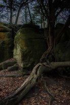
This is a landscape of steep, rushing streams and thickly wooded hills. The land being either sandy and poor or Wealden clay that is almost impermeable to water, agriculture is impractical here and the High Weald still retains the densest covering of woodland in the country. There are numerous outcroppings of the underlying sandstones here, such as at Stone Hill Rocks and Standen Rocks, among others. The bones of the earth being so on display seems almost out of keeping with the image of the South East of England as a “green and pleasant land”, but Sussex has always taken its own path and perhaps this almost secret world of steep narrow valleys and deep, dark woods has placed its influence on the peoples of this part of the world.


