Cres

To the east of Croatia’s Istrian peninsula there lies, amid the deep blue of the Adriatic, an island called Cres (pronounced “Tres”), which my travelling companion has on good authority is “amazing”. And it is thus that we find ourselves stepping down from the Pula – Zagreb coach onto the roadside in tiny Zagore, the sun beating down as we shoulder our packs, slather ourselves in cheap Lidl suncream and start the walk to Brestova to catch the ferry. Of course there’s no public transport to the ferry terminal, so the only option is to walk and we are carrying all of our camping equipment and a fair amount of food and water on our backs. The plan is to catch the ferry to Porozina and walk over the island to Beli where there is a campsite. We’re not sure if we’ll have time to make the whole walk before dark and the suggestion of wild-camping on the way is in the air.

The afternoon sun is hot as we walk down the steeply winding road to Brestova. Occasional cars – German and Italian mostly – sweep past us as we plod on and a coral blue/green snake slithers its way up a nearly sheer cliff-face beside the road as I walk past, small shards of rock tinkling to the ground as it goes. After 45 minutes we make it to the ferry terminal in time for a cooling radler (a kind of shandy made with cloudy lemonade and other flavours like grapefruit. We should do more of this kind of thing in the UK) at the terminal buffet while we wait for the boat. When the boat arrives we troop on, the only backpackers, with a few other foot passengers and go up into the main interior seating area where a lounging steward looks at us in surprise. “Hello” he says, a little gruffly. “Hello” I respond. He looks in askance, an expansive gesture asking the question “What are you doing here?”. “We just got on” I venture. “Ay, ay, ay…” comes the response. We leave and go up to the deck to sit on the rows of seats in the sun for the twenty minute journey to Porozina. Soon the seats fill up, once the cars have come on board and disgorged their passengers and the boat makes its way across the strait to Cres.

IMG_6891IMG_6896

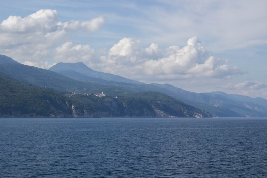
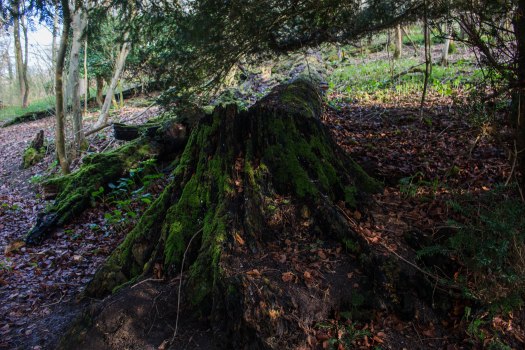
Porozina is a small village set a little above the ferry terminal, with its little shops and cafes, that almost hides from the hordes of tourists that come over on the boat amidst the forest. The main road to Cres Town turns away to the south, but our walking route to Beli takes us up a side road, through the village and then steeply up through the woods, following a rocky track. The way is tough, especially with our packs, but the trees shade us from the worst of the sun and the way, at least to start with, is easy to follow, little red and white target-like way markers are painted on the trees and rocks to keep us on the right path. Soon we have climbed enough for spectacular views to show themselves when we come to occasional clearings in the forest and we sit for a moment to rest and admire them. Wildlife is abundant all around us, especially many beautifully iridescent beetles. We see deer among the trees and hear more than see a number of grunting, snuffling wild boar.

IMG_20180522_184840441IMG_20180522_185310755

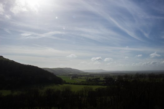
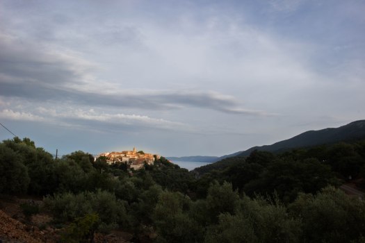
Eventually we make it to the top of the ridge of low mountains that make up the island and start to make our descent. Checking the time, we realise that we have a chance of making it to Beli before nightfall and now that the going is easier we make a little more haste… and promptly get lost. The waymarks that had been so easy to follow are suddenly faded and indistinct and soon we lose them entirely. The map comes out and the compass with it while heads are scratched and various tracks pondered. Eventually we find our way back to the path and, followed by a gang of oddly sinister and persistent sheep, the rocky path between drystone walls gets steeper as we descend towards Beli. I’m beginning to wonder if I’m going to make it by now as I pick my way down the rocky tracks, ever conscious of the possibility of spraining an ankle (something I am annoyingly prone to) when suddenly through a gap in the trees I see the town clustered on its hill against the backdrop of deep blue sea ahead of us, its old stone walls and terracotta roofs glowing honey and gold in the evening sun. Spurred on, we walk to the edge of town and, following a sign, take the long, steep, sweeping road that spirals round the steep hill down to the small harbour at its foot.

IMG_6909IMG_6904

The reception for the campsite is closed. As we stand pondering this a German teenager sitting outside tells us that the campsite itself is closed “But.. you can camp. Just, no water. But there are toilets”. So the camping will be free, which is nice, but there’s no drinking water, which is less nice. We stumble about the campsite in the gathering gloom, failing to find a good spot to pitch our tents. After a while the German girl reappears and tells us that if we go up the hill and into the trees a little there are many places to camp and we soon find a good spot under a pair of olive trees that becomes our home for the next few nights.

IMG_6897

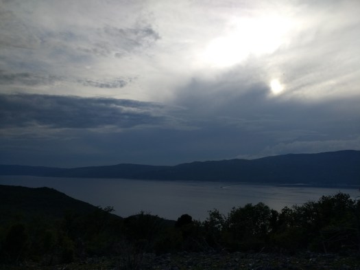
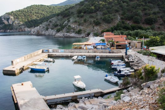
There are two beach bars open at the harbour along with a diving centre, scuba diving being a popular pastime here, and we wonder at the campsite being closed, because it is packed and surely there is money to be made from all these campers. Exhausted, we repair to the bar staffed by a taciturn Herzegovinan gentleman who serves us, his only customers, some beers and goes back to watching a Swedish disaster movie on the enormous TV in the corner. The plot of the movie seems to revolve around a cliff-face that is in imminent danger of collapse into the Baltic which will produce a tsunami and flood a town. As the film reaches its climax and the waves crash into the lines of escaping Volvos, the heavens above Beli itself suddenly open with a crash of thunder and torrents of rain hurl themselves at the canvas roof of the bar. “Tsunami!” Says the barman looking up. How we laughed.

The next day the sun is out and we explore around a little. My friend goes further than me and busies himself clearing up plastic on a beach in a nearby cove while I snooze in my tent. That evening we climb the road back to the town and indulge in the most amazing fish platter for two at one of the local restaurants, followed by the traditional offering of home-made flavoured schnapps as we pay the bill and chat with our friendly host.

IMG_20180523_195950607

The day after we spend mostly splashing in the sea. Or I do at least. My friend is back to his eco-warrior beach clearing. The clear waters are teeming with fish and above us circle one of the things this island is famous for. There is a colony of griffon vultures just along the coast here and we see several over the course of the afternoon. Once common over much of Europe, changing sheep farming practices have seen their numbers severely reduced and they are now protected. Sadly the tourist boats throw rocks at the birds nesting on the cliffs to get them to fly, which leads to many juveniles falling into the water and drowning. Up by our restaurant there is a rescue centre occupying a former school built during the island’s period of Austro-Hungarian rule.

IMG_6910IMG_6916

It is difficult, now, to make a living on the island and many of the houses are empty of permanent residents, holiday-makers now dwell in them in the warmer months. There are no longer children enough in Beli to keep the school open and those that are left are taken by bus to Cres Town for their education. The school bus is the only public transport on the island and it leaves Beli at 7.15am, so we find ourselves slogging back up the hill to catch it far earlier than we would have liked to rise, for we must get to the city of Rijeka on the mainland to catch the coach back to Ljubljana and our flight home. It’s good that there aren’t more tourists wanting to make the journey, because there are only two spare seats on the minibus, which makes its way along extraordinary precipitous, winding lanes to the island’s beautiful capital.

IMG_20180525_075126769IMG_20180525_080506600_BURST000_COVER_TOPIMG_20180525_080909396IMG_20180525_090533814

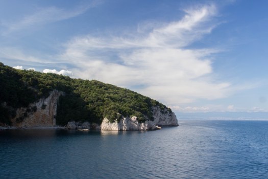
In Cres Town we have only an hour or so to explore the warren of narrow alleys between tall, crumbling houses before our passage, in the form of a catamaran, to Rijeka arrives and whisks us back to the real world of cities and buses and airports. As we leave, we both say that we will come back one day to see more and, if we’re really lucky, taste that wonderful seafood platter beneath the grapevines on the terrace overlooking beautiful Beli – which will live in my memory – once again.

Newtimber Hill

If you drive down the A23 to Brighton, you cannot help but notice the huge, dark bulk of Newtimber Hill suddenly rising ahead of you after you pass under the bridge at the Albourne junction. It’s a sight that has cheered many a weary heart after a long drive home, because when you see it, you know you’re nearly back to Brighton and before you even get there you’ve got the option of sampling the delights of the M&S at Pyecombe Services. The hill is an unusual one on the Downs because it’s wooded and most of this part of the ridge is fairly bare of trees. Indeed only a hundred years ago there was hardly a single tree to be seen on the hills, most of them having been cut down thousands of years ago; intensive grazing ever after keeping any new trees from growing. It was only after the Great War that it became cheaper to import lamb from New Zealand than to rear our own and grazing started to stop on the Downs, leading to new growth. In general it is better to keep the grassland, rather than let scrub grow up as this grassland is rare and supports many endangered flowering herbs that would be unable to grow in shady woodland. The woodland on Newtimber Hill, though, is different.

IMG_6126
The remains of an old beech tree in Newtimber Holt ancient woodland

Much of the woodland on the northern flanks of the hill are ancient woodland. Some of it is regenerated woodland that regrew after the aforementioned cessation of grazing. In fact you can almost tell when looking at the hill from a distance. The newer woodland shows us an almost smooth, green covering. All the trees are about the same age and they are mostly ash, so they’re all the same height. In the older areas, there are many different species, including ash, beech and even some small-leaved lime leftover from the original forests that grew on these slopes. Because the climate is generally cooler now than when those forests first grew after the last ice age, small-leaved lime doesn’t germinate as well as it did then, so some of these trees can be very old indeed. In fact there’s one small-leaved lime tree on Newtimber Hill that may be as much as four thousand years old. It has been coppiced many times (cut down and allowed to regrow into useful poles) and now looks like a ring of large trees, the trunks all growing from the same roots – making the whole thing one single tree.

Besides this incredible tree, the woods are also home to another remarkable natural wonder, this time a beech. In 2015 a beech tree near the bottom of the hill was declared Britain’s tallest native tree at 144ft.

Newtimber Hill will always have a special place in my heart. It is owned by the National Trust and administered from Saddlescombe Farm, just the other side of the hill. I have spent many hours as a volunteer on the Devil’s Dyke Estate, of which Newtimber Hill is a part and it was here that I truly learnt the simple joy that conservation volunteering can bring. When you have spent as much of your life as I have believing yourself to be entirely useless, the effect of doing good work with good people that has palpable results at the end of the day is immeasurable. As I wander the many winding paths in the woods today I still remember places where I cleared a path, or cut some scrub, or that time I delivered crucial biscuits to the wardens working up on the top of the hill. I remember when we made a bonfire so big we could throw whole trees on it (we weren’t cutting the ancient bits down, don’t worry) and when we discovered that great crested newts had returned to a restored dew pond right on the top of the hill – miles from the nearest water. How did they get there? We can only guess.

IMG_6224
Dew pond near the summit of Newtimber Hill

At the foot of the hill is a narrow road called Beggar’s Lane that winds through the trees, from which steps lead up into the woods. Concrete at first, they soon give way to simple mud steps held back by wooden risers. Even after all these years I am never quite sure after the first couple of hundred yards which of the myriad paths I am on, but they are all beautiful. Sometimes winding along the contours, sometimes suddenly snaking up dozens of steps before meeting three other paths all leading off to new, secret places. In the spring there are carpets of anemones and bluebells and many other woodland flowers and you are surrounded by ash, beech, lime, hawthorn and hazel that has been coppiced and worked for thousands of years.

IMG_6136
Steps in Newtimber Holt ancient woodland

Eventually, inexorably, the paths always seem to lead upwards. Higher and higher through the trees until suddenly they emerge onto the bald, grassy top of the hill and when you look to the west, there in front of you is one of the best views in the South East of England. Dyke Hill, Chanctonbury Ring, Cissbury Ring, Bignor Hill and Glatting Beacon are laid out as your eye follows the Downs and then away on the horizon to the north west stands the dark, whale-backed mass of Black Down – the highest point in Sussex. On a clear day to the north you can just see the North Downs, almost beyond the horizon and even the Hog’s Back, a hill in Oxfordshire, some 60 miles away.

IMG_6202
Dyke Hill, wooded on the left. Truleigh Hill with the radio masts on its summit and Chanctonbury Ring visible to its right

On the western part of the hill, the steeper slopes are mostly bare of trees and here you can find some of the best chalk downland in Britain. Studded with tell-tale anthills that prove this land has never been ploughed up, the grassland is home to an incredible variety of flowering herbs and the rare butterflies and other insects that live on them. Near the bottom of this slope is a grove of another rarity: juniper bushes. Needing to drop their seeds on bare ground and then experience two harsh winters before germinating, these fussy shrubs grow in sudden profusion here in one of their few sites in the area.

IMG_6211
An anthill of the yellow meadow ant
IMG_6210
Juniper bushes on Newtimber Hill

And finally, to the south, nestled in its hollow and looking almost as naturally placed as something that has grown there lies ancient, wonderful Saddlescombe Farm, which perhaps I shall write about in greater detail in the future.

IMG_6257
Saddlescombe Farm
IMG_6253
Chalk pit on Saddlescombe Farm. Used into the 20th century as a corral for gathering sheep to be sheared

All over the hill there is evidence of man’s long relationship with it. From the ancient coppiced trees, to man-made dew ponds and chalk pits. There are strip lynchets, evidence of early arable farming around the North Laine (laine means field) and there have been hundreds of findings of worked flints, in one case a pile of knappings that showed the clear outline of a pair of legs belonging to someone who had sat on this same hill that we walk today and worked here thousands of years ago. What did that person look out and see? Perhaps they were making the axes that first cleared the forests and created this uniquely beautiful landscape.

Wandering

I once wrote a song in which I complain that “I sit in my basement flat with never sight of a tree/and as the rain runs down my window I wonder if I’ll ere be free”, and I find myself in a similar position this rainy Easter Monday, as the traditional Bank Holiday weather makes itself felt. In the interests of full disclosure, I must point out that if I actually opened the blinds I would be able to see the two spindly, ivy-encumbered apple trees that dwell in what passes for my back garden and, indeed, the enormous eucalyptus that stands like an alien giant and surveys us all a few gardens up. The song, of course, has more than a streak of self-pity in it and in my defence I wrote it in the living room where you can’t see any trees. Or anything else much other than two wheelie bins, for that matter. What it’s about, of course, is what happens to my brain when I’ve not had access to the countryside for too long. I live in a great, fun city that I love, but if I don’t get to wander free under the sky as often as possible, I start to suffer and city streets are no compensation for country tracks and muddy fields.

There is a primality to walking that is difficult to fully put into words. Something about an act as simple as putting one foot in front of the other that can propel one over mountains. It is an act that humans were built for and that simple act connects us all the way back to the first hominids who stood up to get a better view of their surroundings, their enemies and the way ahead. In many ways, of course, we are separated by eons of history, technology and development, but in many other ways we are still those primal, wary beings, seeking to explore and understand our world. Our post-industrial separation from the land does us as individuals, and our species as a whole, much harm.

Now it is very easy for me to sit here in my centrally-heated flat with its electric lights and its internet connection and its waiting car outside that can whisk me unnaturally to places I choose to walk. There are, of course, many wonders that our industrial world brings us that I would struggle to wish to do without, but that’s not quite the point. We can all make connections with the land that lies beneath our city streets and the landscapes that surround them. Every tree and park. Every garden is a portal into the wild and even though England stands as one of the most managed landscapes in the world, it still keeps those hidden gateways to another, non-human world. A world we choose to ignore at our peril.

Throughout my adult life I have suffered from poor mental health and, particularly, anxiety. There is nothing that calms me more than knowing that I remain a natural being under the sky. That simple act that connects me to those distant ancestors is one that has always helped soothe and replenish what, for want of a better word, I will call my soul. To place my feet in their footprints and follow them is a solace for which I know no comparison, but beyond paying homage to those who went before: it is also a connection to what is real and happening now.

Not all of what can be seen around us in the countryside is cheerful. There is a biodiversity crisis in the fields of Old England. Songbird populations are plummeting. The ash trees are dying; the elm already gone. Hedgerows have disappeared and vast fields spread in sterile, serried grids to horizons shorn of the trees that used to cover them. Yet there is still enough there remaining, scattered and fragmentary though it may be, to allow one, if one pays attention, to look through those windows into the wild and to see that other world and to imagine oneself an earlier human watching the rooks high in the branches of the trees that were once believed to be Gods or entities that connected us to the heavens. We can still stand on the hillsides and look out over the valleys below us and try to discern the way ahead. There is much that is upsetting and difficult, but with that primal vision still somewhere within us, there is always hope.

So I will always look to get out from behind these rain-smeared windows in this basement flat and take myself wandering under the wide open skies of this battered, abused and still intensely beguiling planet of ours. I will continue to place my feet in the footprints of those ancestors that first cleared the paths through the trees and I will remind myself that, even in this world of bright screens and all-pervasive internet coverage, that I am human and I am of the Earth.

Rye Harbour

Well, the time has come. I’m afraid we’re going to have to have a difficult conversation. Oh, I hoped I’d never have to have this talk with you, but I can no longer deny what’s staring us in the face. It’s time to take the bull by the horns and deal with it straight on.

I’m going to have to talk to you about Kent.

Much though we’d like to ignore the Evil County and pretend it just doesn’t exist, there are times when its presence simply has to be acknowledged and in the area around Rye, there’s nothing for it but to accept that it is there and that there is simply nothing to  be done about it. One curious thing about it is that parts of it are even acceptable to upright, proper folk, and those are the parts that were, essentially, made by Sussex.

The River Rother rises near Rotherfield in the High Weald and flows east. At one time it flowed into a large estuary, which also received the waters of several other High Wealden rivers, like the Brede and the Tillingham. At this time the great shingle headland of Dungeness didn’t exist and the whole coastline was quite different to how it is today. Something about the shape of the seabed, however, made a long shingle spit begin to form, starting with a small island out to sea, not far from where Old Romney is today. Eventually the spit joined the island to the shore, creating a lagoon behind it that the rivers continued to empty into. Some people also built a town on the spit and called it Winchelsea. That later turned out to have been a bad idea.

Over time the rivers filled the lagoon with their waters and also their silt. After a while the water became too much and it punched its way through the shingle bank and found its way to the sea once again. As the waters drained out, the silt left behind became salt marshes that, over hundreds of years, were gradually drained and converted to farmland in a process called Inning. Thus, Romney and Walland Marshes and the Rother Levels were created from the mud of the Sussex High Weald and the coastline around Rye Bay was changed forever. So if you’ve ever wondered why Romney Marsh feels less sinister than the rest of Kent, here’s your answer. It is made from the soils and rocks of the Good County to its west.

Eventually the shingle spit was washed away and resurfaced as Dungeness; the old town of Winchelsea departing with it. Edward I founded the present town on its hill nearby. The rivers were forced into new shapes, all of them joining the Rother near Rye and flowing to the sea at Rye Harbour. For a time, before all of the spit had been destroyed, the lagoon survived and was deep enough to shelter several ships in an area behind the old town of Winchelsea known as “La Chambre”, or “The Camber”. Camber Sands and its adjoining town keep this name to this day.

I seem to have gone on rather a bit. Sorry about that. The main point of all this waffle is that there is now a rather beautiful, bleak nature reserve, absolutely teeming with bird life, on the shingle at Rye Harbour and the other day I went for a stroll around it in the wonderfully atmospheric early spring mists and here are some photographs to prove it. I hope you enjoy them.

Sussex

There are six landscape zones stretching across the South East of England, arranged in a series of concentric horseshoes, one inside the other. At the centre of it all lie the oldest rocks in this part of the country: the sandstones of the High Weald. As one passes further out from these hills, the rocks under your feet get progressively younger until, youngest of all, one reaches the chalk of the South and North Downs.

IMG_5490
View across the Weald from Blackcap on the South Downs

The High Weald is a land of rolling, thickly-wooded sandstone hills, reaching from between Hastings and Rye on the coast and inland to Horsham and Tunbridge Wells. Overlaying the sandstones is a layer of impermeable Wealden clay, the combination of the hard, acid rock and the badly-draining clay makes this a very difficult landscape to farm and, as a result, it retains the densest covering of ancient woodland in England. It is from these woodlands, which once covered the whole area between the Downs, that the Weald gets its name, from the Old English Wald, meaning “wood”. Many of the field boundaries and villages are still laid out as they were in medieval times, as the new methods of farming that came with tractors and combine harvesters never came to these parts, where arable crops aren’t keen to grow. As a result, the woods and hedgerows were never cleared to make bigger fields as they were in much of the rest of the country. For many years, the main industry in this area was the production of iron, as both the sandstones and clays are rich in its ores.

Between the hills there run many small, steep and rushing streams that, particularly in the east, coalesce into rivers that have carved long, broad valleys, with villages perched on the ridges between them. Many of the major roads of this region also follow the ridges, affording wonderful views. These rivers run into what were once large, complex estuaries which have, over many hundreds of years, been reclaimed. The Ashbourne into Pevensey Levels and the Rother, Brede and Tillingham into Rye Bay and Romney Marsh, the complicated and fascinating history of which I will discuss at another time. These levels and marshes form the second of our landscape types. All of Sussex’s major rivers, with the exception of the Adur, rise in the High Weald.

Around the outside of the High Weald lies the Low Weald; a broad, clay plain. Again, the heavy clays do not drain easily and while there is more arable farming than in the High Weald, there is still much less than in most of the south of England. As well there are large areas of ancient woodland, but the rivers are broader, slower and more winding than in the High Weald and the landscape more gentle. There are many villages and small towns and the area is more thickly populated than the remoter High Weald.

Next comes the Greensand: a kind of sandstone that supposedly appears green when first exposed to the air. There is a thin ring of it around the outside of the Low Weald, often with little villages and farms perched on top and up in the north west of the county there is a larger area of a slightly different kind of greensand, known as the Greensand Hills. These contain Sussex’s highest point at Black Down. In character they are much like the High Weald, with small, remote-feeling villages, steep valleys, rushing streams and much woodland.

Beyond a very thin ring of gault clay, as hard as rock, we reach the most famous landscape in Sussex, the South Downs. Made of unimaginable billions of coccolithophores – the calcium shells made by single-celled organisms called coccoliths – these chalk hills run for 100 miles from Winchester to Eastbourne. Once thickly wooded, as everywhere else in England, they were cleared between four and six thousand years ago and grazed with sheep, creating a unique grassland that is the most biodiverse habitat in Europe. As there is no natural water on the Downs, they have never been highly populated, but nevertheless they are rich with archaeology, from hill forts like those at Chanctonbury and Cissbury Rings to thousands of tumuli dotted along the ridge. The chalk of the Downs acts like a giant sponge, soaking up rainwater and releasing it in a line of springs along the bottom of the steep northern slope, giving rise to a long line of old villages, built around the access to fresh water and the soil that, mixed with chalk that naturally washes down from the hills and with lime made from baked chalk dug out of pits, is some of the easiest soil to work between the Downs, making this a rare area of many wheat and barley fields.

And finally, beyond the Downs in the south west of Sussex lies an alluvial plain of deep rich silts around Chichester. This is the best arable land in the county and in times past there were many market gardens here, but over time it has become the most densely populated part of this corner of the world and the large towns have brought most of that way of life to an end. Pagham and Chichester Harbours, though, remain among the most beautiful places in Sussex, despite that.

The story of how this land came to be shaped as it is I will leave for another day, but I hope I have been able to give a glimpse at just what a wonderfully varied land this is. One of the greatest joys of Sussex and the wider South East is how quickly the landscapes and the flora and fauna they support change as you drive about, from the tiny winding lanes of the High Weald to the wide open skies of the Levels and from the precipitous, secret valleys of the Greensand Hills to the great glory of the high Downs, where on a clear day one can see for sixty miles across this fascinating patchwork of green.

IMG_4660
The hills where the River Uck rises, High Weald

Blackcap

One place on the South Downs that will always have a special place in my heart is Blackcap near Lewes. As an undergraduate at Plumpton College I wrote a couple of essays on the hill and it’s a place I return to again and again. The clump of trees on top of the hill can be seen for many miles – even from many parts of the High Weald – but despite looking like a black cap, it is not from these trees that the hill gets its name. Where the hill does get its name, on the other hand, is a matter of some debate.

Between the 13th and 17th Centuries the hill was known as Mount Harry, as this is the hill where Henry III stationed his troops before the battle of Lewes in 1264 – a battle that ended with both Henry and his son, the future Edward I, being taken prisoner by Simon de Montfort.  The hill to its east was known as Lewes Beacon and, indeed, it has a beacon on it. For some reason, though, in the 17th century Mount Harry became Blackcap and Lewes Beacon became Mount Harry. No-one really knows why. There was, in that period, a windmill on the saddle between the two hills known as Blackcap Mill, but whether it was named after the hill or vice versa is not known. One thing is certain, though, and that’s that the trees on the very top of the hill were first planted for the coronation of Victoria some 200 years later (they have died and been replaced twice since), so it’s definitely not named after them.

The top of the hill is managed by the National Trust and has been the successful subject of a scheme to regenerate the herb-rich grassland that makes the Downs famous – much of the hill having previously been ploughed up during the Second World War. The large open expanse of the hill affords wonderful views over to the coastal line of the Downs that stretches from Brighton to Eastbourne and in the summer it has one of the finest displays of wild orchids on these hills.

This is a hill that never fails to cheer me up. A network of bostalls scores its northern face, which allows the wanderer to assault it from various directions, or combine it with a walk in the woods and fields of the Low Weald at its feet.

IMG_5488

On my way up the hill today I spotted these King Alfred’s Cakes growing on a dead ash branch. The fungus gets its name, of course, from looking like burnt cakes, such as those supposedly neglected by King Alfred the Great while his mind was on other vaguely important things, like all those pesky Danes that were suddenly cluttering Wessex up. They only grow on dead ash and though they are extremely hard, they can be removed with a knife. Once they have been sliced off and the interior revealed, it can be seen that they have growth rings, just like the trees they grow on, which gives them their Latin name of Daldinia concentrica.

Long before the days of Alfred and his cakes, this fungus had another use. If a spark from a fire were blown onto the inner rings, it would smoulder quite slowly and happily away, even for days, until a new fire was to be set, at which point the addition of some dry tinder – and a fair amount of highly controlled blowing – would bring it back into a bright blaze. A very useful property in the days before we’d worked out how to make fire for ourselves and had to rely on its delivery from the Gods.

With the ash trees all dying of the Chalara fungus, they look set to have a bumper couple of decades, as there’s going to be plenty of dead ash for them to grow on. But after that, I suppose they’ll die out with their hosts. A sad end to such a wonderful part of our human past.

Henfield

On today’s walk I am, for once, actually in the Low Weald. Now, I have a tendency to think of the Low Weald as that bit of Sussex you have to drive across to get to more interesting places, but nevertheless off I set from Henfield down to the Adur (pronounced Ada) to see what I was missing out on. Which turns out to be badly waterlogged fields that proved once and for all that I need new boots. Again.

The Adur used to be navigable up as far as Knepp Castle (which is an interesting place in its own right), which always seems inconceivable considering how small the river is. Large vessels only ever came up as far as Steyning, though. These days they can’t get beyond Norfolk Bridge in Shoreham. The name of the river comes from the Roman fort Portus Adurni, which people in the 17th Century believed was in Shoreham. Turns out it was actually in Portchester, so only 37 miles out. Before it was called the Adur, it was known as the Bramber, after the village and castle, which is a much cuddlier name. Just to the west of Henfield the river divides into western and eastern branches, both of which remain tidal for some distance.

Also today I found some scary rogue ditches, the world’s most over-engineered bench and three cars that have been stuck end-on in the ground for some reason.

Black Down

Much though Sussex prides itself on its independent spirit, there are occasions when other, less worthy counties impose themselves upon us and it is somehow ironic that the highest point of this blessed land is, in fact, an outpost of the Surrey Hills. Having said that, the Surrey Hills themselves are a mere part of the Greensand Ridge that runs in a giant horseshoe around the outside of the Low Weald, so perhaps we can learn to share our topography nicely with our neighbours. Black Down sits at the end of a promontory of sandstone that looms over the wide clay vale of the western Low Weald and, as a result, commands wonderful views; especially at its southern end, where the land steeply falls some 200 metres to meet the plains that spread below.

Such a significant hill has, of course, been important for millennia. The slopes are littered with prehistoric worked flints – some 2000 of them are in the collection of Haslemere Educational Museum just to the north. Flint does not naturally occur in the acid sandstones of these hills, so they must have been brought here by prehistoric man and the fact that most of these flints are arrowheads shows that this hill was an important hunting ground for these people.

For thousands of years the hill, like the chalk Downs, was grazed, which kept the trees down and allowed a large open heath to develop. The slopes are still covered with thick heather and hair grass, but since regular grazing stopped in the early years of the last century, Scots pine has taken much of the area over. This being a National Trust property, they are gradually thinning the pine and restoring grazing to allow the heather and its attendant rare wildlife to thrive. I didn’t see any of their belted galloway cattle on this occasion, but I have seen them among the trees on previous visits.

The hill’s most famous resident must be Tennyson, who died in his house here in 1892. One of the deep, winding lanes is named in his honour. Long walks over the heath were taken by the poet and his friends and the place remains extremely popular with walkers of all kinds, its proximity to the town of Haslemere adding to its attraction.

Droke

That morning I awoke with a feeling of complete uselessness. Nothing I had or could do seemed to have any meaning and the temptation to remain in bed, with the blinds closed and the only light provided by a laptop screen was strong upon me. “Ah.” I thought. “Another day of pointless existence, I see. I suppose I’d better get on with it.”

I forced myself to go to a place called Droke. I’d first found it years before while exploring West Sussex by car. It sits in a long dry valley of the Downs which runs parallel to where the steep northern edge of the long line of hills descends to the Low Weald. The name intrigued me, redolent as it is of some elemental Jansson-esque monster of the woods. In fact, the name turns out simply to mean “steep-sided valley”. This is a timeless, lost place high in a landscape that has never been able to support large amounts of human life. What villages and farms exist are few, small, scattered and achingly beautiful. Charlton Forest is just to the north and one of the largest areas of woodland in Sussex – leading up to the top of the north scarp of the Downs – and I’d wanted to explore it for years. I was in an ambivalent mood as I drove there. That feeling in the pit of my stomach of not really knowing what I was doing or why.

The feeling persisted as I walked through mile after mile of beech plantation, almost as mono-cultural as a stand of pine with just a muddle of bramble at the field layer, a few dark yews dotted about and the odd hazel at the edges. All of that changed at a medieval wood bank near the summit, after which I was suddenly in oak/ash woodland with a significant coppiced hazel under-storey, a fair amount of hawthorn and wild cherry filling it out and moss everywhere.


The top was muddy as all hell, but some fine views fading into the soft winter haze over towards Harting Down and the Surrey Hills made up for it. I was just beginning to really tire of slogging through the mud when all of a sudden the woodland ended and one of the most beautiful dry valleys in the Downs opened up at my feet. The sun came out and I stood and watched a buzzard wheeling against the sky above me. Through a parting in the trees I caught a sudden glimpse of Chanctonbury Ring away in the distance, almost back at Brighton and as I took it all in I thought to myself: “Ah yes. This is the point.”


The hill down to Upwaltham was steep and after spending 20 minutes or so poking around in the beautiful old church of nearly 900 years, I abandoned my original plan of walking over Upwaltham Hill and Selhurstpark Hill to get back to Droke and took the quicker route along the road, as the sun was now nearing the western horizon. The sound of gunfire filled the air as I walked along Droke Lane, the guns lined up with their dogs in the fields like so many waiting statues.

Dudwell Valley

Few villages in Sussex occupy a more enviable position than Burwash and its neighbour Burwash Weald sitting high up on one of the great east-west ridges of the eastern High Weald. In days past they must have been even more beautiful, before main roads and ranks of parked cars came along with all their ugly convenience. Burwash sits particularly prettily on its ridge and the buildings along the main road remain very handsome to this day. To the north runs the greatest of the three main rivers that run east to Rye Bay – the East Sussex Rother (not to be confused with the West Sussex Rother, itself a tributary of the Arun. Or the Yorkshire Rother, come to that). To the south is, to my mind, one of the most beautiful parts of the High Weald, if not of Sussex in general.

A small river, never much more than a large stream really, the Dudwell has nevertheless carved a deep, steep valley between the ridges occupied by the Burwashes to the north and Dallington and Brightling to the south. The acidity of the underlying sandstone is much in evidence here and many of the paths and tracks are bordered with hedges made of gorse. The impermeable layer of Wealden clay that covers it also makes its presence felt – the fields quickly becoming waterlogged and difficult to negotiate in wet weather.

The whole is covered with a patchwork of pasture and dense woodland, with many rushing, falling streams running among them. Scattered farms and oast houses perch on the hills and ridges between them, commanding wonderful views down the valley towards where the Dudwell finally reaches the Rother at Etchingham.

%d bloggers like this: