

Look! A map! Exciting! Also, definitely hover over the pictures and click on them to get my hilarious and informative captions.
If there’s one place on all of the beautiful South Downs that I keep returning to, it’s the area around Bignor Hill in West Sussex. The jury’s still out on whether it’s the “best part of Sussex” (There’s at least six or seven “best parts of Sussex”. Maybe I’ll do a list), but it’s certainly one of the most gloriously rural parts of the long stretch of the Downs, allowing one to walk for miles without being disturbed by the sound of a car. A lot of the East Sussex Downs are, of course, very beautiful, but almost always there is a fairly major road at the bottom of the hill, or not too far away so there’s always that reminder going on in the background that the real world (Hmm. Maybe that world is unreal and the world of hills and woods is the real one?) is hurrying on and making sure you know about it. Newtimber Hill is achingly beautiful, but the constant roar of the A23 puts a definite dampener on it.
None of this is a problem at Bignor and, aside from the occasional car that makes it up to the National Trust car park at the top (following the old Roman Stane Street for part of the way), you are left to the natural sounds of Sussex: the birds, the wind in the trees, the people shouting at dogs… I mean, you can’t have everything. This is Sussex after all. It’s never going to be wilderness.
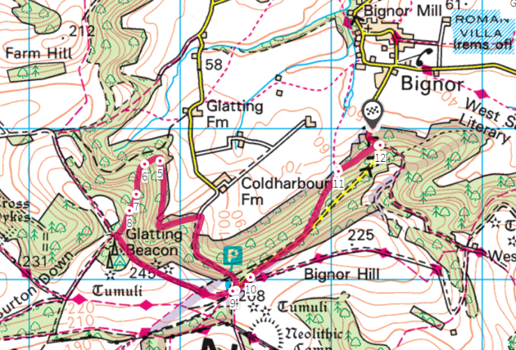
I’ve usually, in the past, done much the same walk every time I’ve been up the Hill; which is to loop around via Glatting Beacon and Barlavington Down and back across the Weald to the car, which I’ve tended to leave in Bignor village itself, or (as I did today) at the bottom of the hill on the road up to the car park. Today, though, I thought I’d explore around a bit more, so I parked at the bottom of the hill where there’s space to leave the car while still leaving enough room for others to use the passing space and, at first, took my familiar route to the top. As you walk up the road you enter a wonderfully deep bostall and just after that section, before the road bends sharply to the right, there is a track leading off to the right. It’s not an official path, but this is all access land and part of the National Trust’s Slindon Estate, so we have the right to roam on it. This beautiful track leads through the trees to an actual public footpath (where there is a wonderful view over the fields, peeping out from under the eaves of the wood). Turning left the footpath leads fairly steeply up the hill, rejoining the road a hundred yards or so from the top. You could walk up the road itself if you wanted, but this way is nicer.


Having gained the car park, there’s then almost immediately a track off to the right going back down again, which I followed back down to and then along the edge of the woods. At the far end of the access land there is, according to the map, a track that goes back up to Glatting Beacon. Let me tell you something. This track does not exist. Neither is it possible to tell where the access land ends and private woodland begins. Nevertheless I headed up the hill, following what may have been an overgrown trackway, or bostall, or cross dyke or something. Despite the steep gradient I made fairly easy progress, there not being too much undergrowth and found the main track again at Glatting Beacon. This I followed back to the car park and then back the way I’d come to the car.


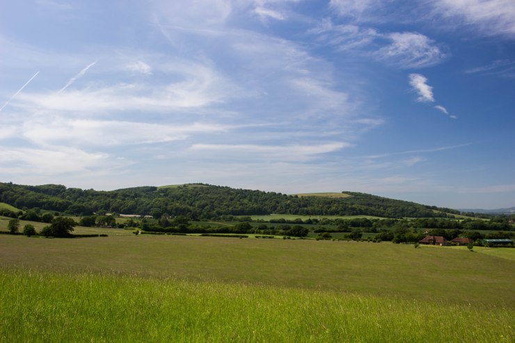
One thing that sets the more westerly Downs apart, aside from their generally more rural nature, is that they are much more wooded than their eastern counterparts. While much of the Downs was cleared of trees thousands of years ago to make way for the grazing of sheep, large areas were planted with useful trees to grow – as a supply for the local shepherds and farmers and as a cash crop. There are large areas of hazel and a great deal of ash (suffering, sadly, quite badly here from the dieback fungus), but in particular mighty, beautiful beech trees were grown, coppiced roughly every 250 years, in woodlands on the steeper slopes known as “hangers”. The woodland I was mostly in today is known as Lamb Hanger, thus neatly encapsulating the two primary purposes of the Downs in one name. Beech woodland has to be one of the most beautiful forms of woodland on earth. The tall, elegant, smooth-grey trunks of these enormous, yet most graceful trees. The fresh, bright green of the canopy in spring and summer, replaced by the most wonderful coppery gold in the autumn and winter, the old leaves eventually falling to carpet the ground with gentle gold as the next season’s growth unfolds above them.


Traditional management of beech hangers has, in many cases, ceased and these wonderful trees are left to die. This isn’t necessarily a bad thing. Beech naturally starts to fall apart as it gets older (it gets every disease under the sun too) and eventually the trees come to the end of their lives leaving a large amount of both lying and standing dead wood. Both are wonderful for different insects, known as decomposers, which will slowly consume the old, rotting timber. Standing dead wood also provides potential places for woodpeckers to make their nests. Beech also reseeds itself quite freely, so there seems little danger of it becoming a thing of the past on the Downs. It seems a shame, though, for all that beautiful wood to go to waste. Beech is perfect for making furniture from, but such is economics, I suppose.


