Bedham

Bedham
©Crown copyright 2018 Ordnance Survey. Media 076/18. Landranger: Sheet 197
Bedham wider
©Crown copyright 2018 Ordnance Survey. Media 076/18

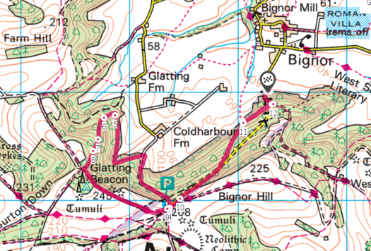
Somewhere to the north of Fittleworth in the Greensand Hills of West Sussex there lies, lost in the woods, a tiny, tiny little place that goes by the name of Bedham. The place is so small that it didn’t have its own church or school until late in the 19th century and when they were built, they were both in the same, small building – built out of brick and the local, golden sandstone. The little school/church didn’t last very long and now stands as a maintained ruin, lacking its roof and the lean-to side buildings that once stood. The walls have been prevented from falling into further decay with repointing and steel girders to hold up the precarious bell-cot.

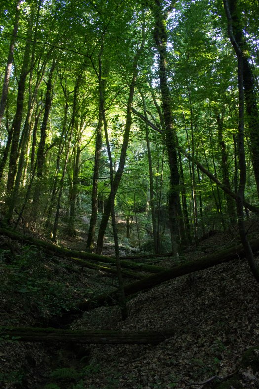
I have tried to find out if there is a single name for these woods, but the internet is, thus far, silent on the matter. They stretch north from Bedham including areas with names like Hammonds Wood, Hoghurst Copse and The Mens. There are huge, ancient trees here including some glorious, vast, coppiced beech whose great boughs have grown over the thousand-year ghosts of the people that first cut these trees and harvested their wood.

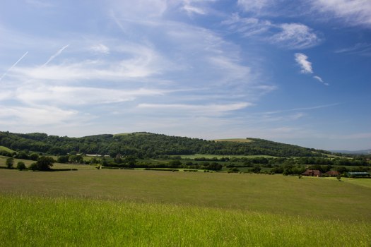
There are paths and tracks through the trees – some easier to follow than others – but to make a circular walk out of it I struck away from the path and followed, as best I could, the streams to get back to the car. The day above the canopy was bright and warm, but I walked and scrambled in the cool, eons-long gloom of the trees. The gloom of the woods that becomes a portal to an older world. A gloom that has persisted in smaller and smaller pockets since the ice retreated 9000 years ago and the great primeval forests that once covered this land first grew. These are the woods that humans found when they first came back to Britain and where they made their homes. This is where they cut the trees and made their clearings and knew that the woods that surrounded them held both essential assets and hidden dangers. Boar and wolves and bears once lived in these woods and to leave the clearing was a dangerous, but necessary pursuit. European folk tales are filled with stories of woodland as a transitional, transformative landscape: somewhere the young girl or boy can go and be changed. They may not come to a good end, or they may triumph over whatever lurks behind the the trunks of the mighty beeches and in the thickets of holly: but whatever their fate you can guarantee that they will not be the same when they emerge once more into the human world of light and order.

As I walked I followed tracks made, not by humans, but by other path-finders of the forest – mostly deer, of which I saw several – always bounding gracefully out of sight before I could bring my camera to bear on them. The old human paths are, mostly, gone. Even some of the ones marked on the map have faded as the trees take back their gloom; but there are other clues here that speak of labouring men and women in years gone by. There are medieval wood banks here, built to mark the edges of properties, and coppiced beech with some hazel stools stand testament to lives at which we can only guess.

And deep in the woods there were surprises. A shelter built far from the nearest path. A clearing containing a shepherds’ hut. A bridge over one of the deeper ghylls – broken and twisted by the floods of winter, but still crossable with care.

There is always such a powerful feeling of walking among the fallen and disappearing past when you walk in these old woods. Some of these trees have long memories, but not so long that the old ghosts of past millennia won’t, in the end, pass fully away and be forgotten even by the ancient beeches – once kept alive by coppicing, they now grow old and fall in a ruinous, rotting confusion of limbs. An ancient way of life is passing from us. The spirits these trees once held have flown, only to be remembered by the few who care to know what our ancestral explorers, clearers and farmers once worshipped.

IMG_7173

Lamb Hanger

Look! A map! Exciting! Also, definitely hover over the pictures and click on them to get my hilarious and informative captions.

Lamb Hanger 6.6.18
©Crown copyright 2018 Ordnance Survey. Media 076/18. Landranger: Sheet 197
Lamb Hanger Wider 6.6.18
©Crown copyright 2018 Ordnance Survey. Media 076/18

If there’s one place on all of the beautiful South Downs that I keep returning to, it’s the area around Bignor Hill in West Sussex. The jury’s still out on whether it’s the “best part of Sussex” (There’s at least six or seven “best parts of Sussex”. Maybe I’ll do a list), but it’s certainly one of the most gloriously rural parts of the long stretch of the Downs, allowing one to walk for miles without being disturbed by the sound of a car. A lot of the East Sussex Downs are, of course, very beautiful, but almost always there is a fairly major road at the bottom of the hill, or not too far away so there’s always that reminder going on in the background that the real world (Hmm. Maybe that world is unreal and the world of hills and woods is the real one?) is hurrying on and making sure you know about it. Newtimber Hill is achingly beautiful, but the constant roar of the A23 puts a definite dampener on it.

None of this is a problem at Bignor and, aside from the occasional car that makes it up to the National Trust car park at the top (following the old Roman Stane Street for part of the way), you are left to the natural sounds of Sussex: the birds, the wind in the trees, the people shouting at dogs… I mean, you can’t have everything. This is Sussex after all. It’s never going to be wilderness.

IMG_7041
Barlavington Down

I’ve usually, in the past, done much the same walk every time I’ve been up the Hill; which is to loop around via Glatting Beacon and Barlavington Down and back across the Weald to the car, which I’ve tended to leave in Bignor village itself, or (as I did today) at the bottom of the hill on the road up to the car park. Today, though, I thought I’d explore around a bit more, so I parked at the bottom of the hill where there’s space to leave the car while still leaving enough room for others to use the passing space and, at first, took my familiar route to the top. As you walk up the road you enter a wonderfully deep bostall and just after that section, before the road bends sharply to the right, there is a track leading off to the right. It’s not an official path, but this is all access land and part of the National Trust’s Slindon Estate, so we have the right to roam on it. This beautiful track leads through the trees to an actual public footpath (where there is a wonderful view over the fields, peeping out from under the eaves of the wood). Turning left the footpath leads fairly steeply up the hill, rejoining the road a hundred yards or so from the top. You could walk up the road itself if you wanted, but this way is nicer.

Having gained the car park, there’s then almost immediately a track off to the right going back down again, which I followed back down to and then along the edge of the woods. At the far end of the access land there is, according to the map, a track that goes back up to Glatting Beacon. Let me tell you something. This track does not exist. Neither is it possible to tell where the access land ends and private woodland begins. Nevertheless I headed up the hill, following what may have been an overgrown trackway, or bostall, or cross dyke or something. Despite the steep gradient I made fairly easy progress, there not being too much undergrowth and found the main track again at Glatting Beacon. This I followed back to the car park and then back the way I’d come to the car.

One thing that sets the more westerly Downs apart, aside from their generally more rural nature, is that they are much more wooded than their eastern counterparts. While much of the Downs was cleared of trees thousands of years ago to make way for the grazing of sheep, large areas were planted with useful trees to grow – as a supply for the local shepherds and farmers and as a cash crop. There are large areas of hazel and a great deal of ash (suffering, sadly, quite badly here from the dieback fungus), but in particular mighty, beautiful beech trees were grown, coppiced roughly every 250 years, in woodlands on the steeper slopes known as “hangers”. The woodland I was mostly in today is known as Lamb Hanger, thus neatly encapsulating the two primary purposes of the Downs in one name. Beech woodland has to be one of the most beautiful forms of woodland on earth. The tall, elegant, smooth-grey trunks of these enormous, yet most graceful trees. The fresh, bright green of the canopy in spring and summer, replaced by the most wonderful coppery gold in the autumn and winter, the old leaves eventually falling to carpet the ground with gentle gold as the next season’s growth unfolds above them.

Traditional management of beech hangers has, in many cases, ceased and these wonderful trees are left to die. This isn’t necessarily a bad thing. Beech naturally starts to fall apart as it gets older (it gets every disease under the sun too) and eventually the trees come to the end of their lives leaving a large amount of both lying and standing dead wood. Both are wonderful for different insects, known as decomposers, which will slowly consume the old, rotting timber. Standing dead wood also provides potential places for woodpeckers to make their nests. Beech also reseeds itself quite freely, so there seems little danger of it becoming a thing of the past on the Downs. It seems a shame, though, for all that beautiful wood to go to waste. Beech is perfect for making furniture from, but such is economics, I suppose.

Black Down

Much though Sussex prides itself on its independent spirit, there are occasions when other, less worthy counties impose themselves upon us and it is somehow ironic that the highest point of this blessed land is, in fact, an outpost of the Surrey Hills. Having said that, the Surrey Hills themselves are a mere part of the Greensand Ridge that runs in a giant horseshoe around the outside of the Low Weald, so perhaps we can learn to share our topography nicely with our neighbours. Black Down sits at the end of a promontory of sandstone that looms over the wide clay vale of the western Low Weald and, as a result, commands wonderful views; especially at its southern end, where the land steeply falls some 200 metres to meet the plains that spread below.

Such a significant hill has, of course, been important for millennia. The slopes are littered with prehistoric worked flints – some 2000 of them are in the collection of Haslemere Educational Museum just to the north. Flint does not naturally occur in the acid sandstones of these hills, so they must have been brought here by prehistoric man and the fact that most of these flints are arrowheads shows that this hill was an important hunting ground for these people.

For thousands of years the hill, like the chalk Downs, was grazed, which kept the trees down and allowed a large open heath to develop. The slopes are still covered with thick heather and hair grass, but since regular grazing stopped in the early years of the last century, Scots pine has taken much of the area over. This being a National Trust property, they are gradually thinning the pine and restoring grazing to allow the heather and its attendant rare wildlife to thrive. I didn’t see any of their belted galloway cattle on this occasion, but I have seen them among the trees on previous visits.

The hill’s most famous resident must be Tennyson, who died in his house here in 1892. One of the deep, winding lanes is named in his honour. Long walks over the heath were taken by the poet and his friends and the place remains extremely popular with walkers of all kinds, its proximity to the town of Haslemere adding to its attraction.

Droke

That morning I awoke with a feeling of complete uselessness. Nothing I had or could do seemed to have any meaning and the temptation to remain in bed, with the blinds closed and the only light provided by a laptop screen was strong upon me. “Ah.” I thought. “Another day of pointless existence, I see. I suppose I’d better get on with it.”

I forced myself to go to a place called Droke. I’d first found it years before while exploring West Sussex by car. It sits in a long dry valley of the Downs which runs parallel to where the steep northern edge of the long line of hills descends to the Low Weald. The name intrigued me, redolent as it is of some elemental Jansson-esque monster of the woods. In fact, the name turns out simply to mean “steep-sided valley”. This is a timeless, lost place high in a landscape that has never been able to support large amounts of human life. What villages and farms exist are few, small, scattered and achingly beautiful. Charlton Forest is just to the north and one of the largest areas of woodland in Sussex – leading up to the top of the north scarp of the Downs – and I’d wanted to explore it for years. I was in an ambivalent mood as I drove there. That feeling in the pit of my stomach of not really knowing what I was doing or why.

The feeling persisted as I walked through mile after mile of beech plantation, almost as mono-cultural as a stand of pine with just a muddle of bramble at the field layer, a few dark yews dotted about and the odd hazel at the edges. All of that changed at a medieval wood bank near the summit, after which I was suddenly in oak/ash woodland with a significant coppiced hazel under-storey, a fair amount of hawthorn and wild cherry filling it out and moss everywhere.


The top was muddy as all hell, but some fine views fading into the soft winter haze over towards Harting Down and the Surrey Hills made up for it. I was just beginning to really tire of slogging through the mud when all of a sudden the woodland ended and one of the most beautiful dry valleys in the Downs opened up at my feet. The sun came out and I stood and watched a buzzard wheeling against the sky above me. Through a parting in the trees I caught a sudden glimpse of Chanctonbury Ring away in the distance, almost back at Brighton and as I took it all in I thought to myself: “Ah yes. This is the point.”


The hill down to Upwaltham was steep and after spending 20 minutes or so poking around in the beautiful old church of nearly 900 years, I abandoned my original plan of walking over Upwaltham Hill and Selhurstpark Hill to get back to Droke and took the quicker route along the road, as the sun was now nearing the western horizon. The sound of gunfire filled the air as I walked along Droke Lane, the guns lined up with their dogs in the fields like so many waiting statues.

Penhurst

When first I arrived in Sussex I did what I always do in a new place, which is get in my car and start to explore. Driving out from Brighton along Ditchling Beacon Road, I soon found myself at the highest point in East Sussex, the Beacon itself, and what a view was laid out before me. Coming from Suffolk, which – beautiful though it is – is not known for its extensive vistas, it was amazing to stand on a point in the south east of England and be able to see so much country at my feet. Over time I would learn what I was looking at. I’d know which hills on the far horizon were part of the Greensand Ridge and which, seen only on the clearest days, were the North Downs away on the edges of London. I’d come to learn about the two Wealds – High and Low –  and how they were formed and I’d start a process of exploration, by foot and by car, that would lead to a truly abiding love for this wonderful corner of England.

Now, there are many beautiful places and areas in Sussex, of course, but the crowning glory of the county, to my mind, has to be the High Weald (there’s a whole High Weald article brewing) and probably the best part of that is the area around Penhurst and Brightling. I must have driven countless times along the lanes around there and paused in gateways, gazing out over the hills, the South Downs a faint shadow on the horizon; almost like a line of low cloud on the edge of consciousness.

This area is not like the eastern parts of the High Weald (which is a fascinating and beautiful region in its own right) with its long, wide, open valleys with high ridges between, topped by the villages so characteristic of the area. Those valleys were carved out by the bigger rivers which empty into Rye Bay – the Rother, the Brede and the Tillingham and their stories are long and intriguing ones, but there are other, smaller rivers and streams that have carved a web of deep, steep valleys into the sandstone rocks, creating a wonderfully complex landscape both secret and dramatic by turns.

Penhurst is a tiny, tiny village. A fine manor house, a church of honey-coloured local stone and a few barns and that’s pretty much it – the rest of this most rural of parishes being made up of scattered farms and cottages. It sits high among the headwaters of a small river that is named as the Ash Bourne on the OS map and which I have also seen referred to as the River Ashbourne in other places. This river doesn’t flow to the east, but almost due south until it leaves the steep valleys and rushing streams of its youth and becomes a slow, deep, winding river known as Waller’s Haven that snakes lazily across Pevensey Levels, before finding the sea via sluices at Norman’s Bay.

After all these years of driving through this wonderful little place, I am happy to have finally parked the car, got my boots on and done some of the real exploration that can only be done on foot.

Gravetye Estate

What a find! The estate of the Elizabethan former manor house of 1598, the whole lot was left to the Forestry Commission on the death of former owner William Robinson, who also created renowned gardens around the house, which are now open under restrictions. The house became a hotel and Michelin starred restaurant.

Because the estate is managed by the Forestry Commission, the whole lot is designated as Access Land and the public have the right to roam across all of it. Unlike most Forestry Commission properties it is far from being uniform pine plantation, but is in fact a wonderful extensive patchwork of woods, fields, lakes and streams laid over rolling hills and with the old manor house still set at its heart.

Bedham Church

Now, I don’t know how you spend your evenings, but I spend quite a lot of mine looking at Ordnance Survey maps. Mostly, of course, I’m looking for places with rude names (Wellcombe Bottom being a particular favourite), but also I’m looking for places that might be nice for a walk. One such place is an area of open access woodland I noticed to the north of Fittleworth in West Sussex (Fittleworth of course is not a rude name, exactly, but it’s still an awesome one). Today being a nice day, I decided to go and have a look… And found this! Built as a church and a school in 1880, it stopped being used for education in 1925 and for worship in 1959.

A Few Extra

A collection of a few pics that, for one reason or another, weren’t part of other sets, or haven’t been posted before. Hover and click for descriptions.

Ash

IMG_2259

Another of Britain’s biggest trees, similar in stature to the Oak, is the Ash. Its limbs are straighter, its shoots burst from the parent branch in strangely geometric opposite pairs and its frond-like leaves seem almost alien in this land of broadleaves – almost as though some survivor of a more ancient age still stands among us. Like the Oak it is a large, heavy-limbed tree with deeply fissured bark. In many cultures it is seen as protective and nowhere more so then in Norse mythology where the World Tree Ygdrassil is an Ash tree found on an island in a lake containing the World Serpent. Ygdrassil was so mighty it reached from the depths of the lake to the very heavens, its limbs reaching out over the world it protected and its trunk providing a means of transport between the Nine Worlds with messages borne by a squirrel from the serpent at its base to the eagle high in its crown. The rivers of the world flowed from the antlers of a deer which ate Ygdrassil’s leaves. The Anglo Saxons knew the Vikings as the “Aescling” or Men of Ash.

In British folklore the tree retains its protective qualities. It is often seen as protecting the purity of wells and a spoonful of ash sap would be given to newborn babies to ensure good health. If a child became ill, a cleft would be made in an ash tree and the naked child would be passed through, the cleaving being bound after the event, so as the child healed, the tree healed with it and the two became linked for life.

Ash was one of the most-worked trees in the woodlands of old. Preferring the less acidic soils it grows with enormous vigour, growing quickly and in great proliferation. Indeed it is often seen as something of a pest. Its wood is strong and flexible, giving it a vast range of uses for the woodsman and carpenter alike. Shepherds used it to make their hurdles to contain their sheep, joiners used it to make frames (it was said a joint of ash wood would bear more weight than any other) and its elastic nature made it the first choice for many tool handles, especially for axes; the natural give in the wood absorbing the shock of repeated blows as a tree was cut down or logs split. Wheelwrights prized Ash for use as the fellowes, or rim of the wheel, its forgiving properties allowing it to ride over rough terrain without splitting. Axles were also made from Ash because of this.

The Latin name for Ash is Fraxinus, which means “firelight”, but unlike Oak which was associated with cataclysmic fire from the skies, the fire of the Ash was often a far more domestic affair, it being known to be the best firewood, even to this day. It will burn green or seasoned and burns well for a long time.

In times of war spears and arrow shafts and sometimes even bows were made from Ash. Indeed a poetic Anglo Saxon name for a spear was “aesc”. Both Odin and Thor had spears made of Ash.

Ash was often coppiced and this can continue a tree’s life almost indefinitely, the stools growing to considerable widths. If not coppiced the trees would be left to grow to full maturity before being cut for use in the many ways described above and more. Our ancestors must have been in awe of this most useful of trees and it is possible to imagine how such a tree could become seen as a great protector as in very real ways that’s just what it was.

In 2012 a fungus called Chalara and also known as Ash Dieback was found in the UK for the first time. It had been widely known across Europe since 1992. The fungus causes lesions in the bark, the death of leaves and the reduction of the crown of the tree. Once a tree is infected it is usually fatal, either the tree loses so much of its leaves it is no longer able to photosynthesise, or it is so weakened it can be killed by other pathogens. Already over 90% of Ash trees in Scandinavia have been killed and similar numbers are expected to die in the UK. However, ash grows so rapidly and so freely there are high hopes that even after such a strong attack, tree numbers will eventually recover from naturally resistant stock. Let us hope so. After all, how will the Gods move between the Nine Worlds if Ygdrassil is dead?

Darwell Wood and Reservoir

The path fell steeply away at my feet as I entered Darwell Wood and I was quickly deep in the quiet, dreaming woodland. I could see on the map that I wasn’t far from the reservoir, but I couldn’t see it. My heart sank a little and I wondered if it would be the same as Weir Wood Reservoir, where only the barest glimpses of the water can be caught from the path and a high fence prevents getting any nearer. The path brought me to the long, gently winding incongruous sight of a covered conveyor belt, running through the trees: there are gypsum mines in these woods and the conveyor stretches for just under 5km between them. Turning away, the footpath drops once again and suddenly, to my delight, I could see the water through the trees. Fighting my way through dense willows, I emerged on the shore. What a beautiful place. I didn’t want to leave, but leave I did and looped back round through the woods to the car.

%d bloggers like this: